Hranice geodata
Hranice (Karlovarský kraj) is a populated place; located in Czech Republic in Europe/Prague (GMT+2) time zone. With population of 2,268 people, there are 570 cities with bigger population in this country. Compared to other cities in Czech Republic, 83.7% of cities are located further ↓South; 100% of cities are located further →East and 94.9% of cities have lower elevation than Hranice. Note1


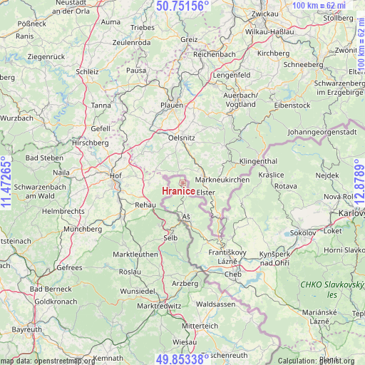
Hranice GPS coordinates[2]
50° 18' 16.524" North, 12° 10' 32.772" East
| Map corner | latitude | longitude |
|---|---|---|
| Upper-left | 50.75156°, | 11.47265° |
| Center: | 50.30459°, | 12.17577° |
| Lower-right: | 49.85338°, | 12.8789° |
| Map W x H: | 99.9×99.9 km | = 62.1×62.1mi |
| max Lat: | 51.01104° ⇑16.3% North |
| Hranice: | 50.30459° |
| min Lat: | ⇓83.7% South 48.60378° |
| min Long | Hranice | max Long |
| 12.17577° | 12.17577° | 18.82683° |
| W 0%⇐ | ⇒100% E |
Elevation
Elevation of Hranice is 580 m = 1903 ft, and this is 228 m = 748 ft above average elevation for this country.
| Max E: |
901 m = 2956 ft | 5.1% |
| Hranice | 580 m 1903 ft | |
| Avg. | 352 m = 1155 ft | |
Min E: |
136 m = 446 ft | 94.9% |
See also: Czech Republic elevation on elevation.city.
Geographical zone
Hranice is located in North temperate zone (between Tropic of Cancer and the Arctic Circle). Distance of this North polar circle is 1807.8 km =1123.3 mi to North.| Distance of | km | miles | from Hranice |
|---|---|---|---|
| North Pole | 4413.7 | 2742.5 | to North |
| Arctic Circle | 1807.8 | 1123.3 | to North |
| Tropic Cancer | 2987.4 | 1856.3 | to South |
| Equator | 5593.3 | 3475.5 | to South |


Nearby cities:
15 places around Hranice: (largest is in red/bold)
• Aš
9.1 km =5.7 mi,  171°
171°
• Bukovany
32.1 km =19.9 mi,  118°
118°
• Cheb
28.7 km =17.8 mi,  150°
150°
• Františkovy Lázně
24 km =14.9 mi, 148°
• Habartov
29.9 km =18.6 mi, 116°
• Hazlov
17.9 km =11.1 mi,  157°
157°
• Krajková
27.3 km =17 mi,  111°
111°
• Kraslice
24.4 km =15.2 mi,  84°
84°
• Libá
20 km =12.4 mi, 168°
• Luby
17.4 km =10.8 mi, 109°
• Nový Kostel
21.5 km =13.4 mi, 116°
• Oloví
27.9 km =17.3 mi,  102°
102°
• Plesná
15.3 km =9.5 mi,  127°
127°
• Rotava
28.3 km =17.6 mi,  91°
91°
• Skalná
19.9 km =12.4 mi,  138°
138°
Sources, notices
• [Note1] Compared only with cities in Czech Republic existing in our database
• [Src1] Map data: © OpenStreetMap contributors (CC-BY-SA)
• [Src2] Other city data from geonames.org with taken over terms of usage.
• [Src3] Geographical zone / Annual Mean Temperature by Robert A. Rohde @ Wikipedia
