Horní Domaslavice geodata
Horní Domaslavice (Moravskoslezský) is a populated place; located in Czech Republic in Europe/Prague (GMT+2) time zone. With population of 565 people, there are 2251 cities with bigger population in this country. Compared to other cities in Czech Republic, 54.1% of cities are located further ↑North; 98.6% of cities are located further ←West and 55.5% of cities have higher elevation than Horní Domaslavice. Note1
Administrative division(s):
- Level 1: Moravskoslezský
- Level 2: Okres Frýdek-Místek
- Level 3: Horní Domaslavice


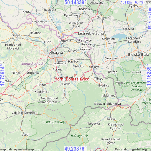
Horní Domaslavice GPS coordinates[2]
49° 41' 44.52" North, 18° 27' 33.336" East
| Map corner | latitude | longitude |
|---|---|---|
| Upper-left | 50.14839°, | 17.75614° |
| Center: | 49.6957°, | 18.45926° |
| Lower-right: | 49.23876°, | 19.16239° |
| Map W x H: | 101.1×101.1 km | = 62.8×62.8mi |
| max Lat: | 51.01104° ⇑54.1% North |
| Horní Domaslavice: | 49.6957° |
| min Lat: | ⇓45.9% South 48.60378° |
| min Long | Horní Domaslav | max Long |
| 12.17577° | 18.45926° | 18.82683° |
| W 98.6%⇐ | ⇒1.4% E |
Elevation
Elevation of Horní Domaslavice is 311 m = 1020 ft, and this is 41 m = 135 ft below average elevation for this country.
| Max E: |
901 m = 2956 ft | 55.5% |
| Avg. | 352 m = 1155 ft | |
| Horní Domaslavice | 311 m = 1020 ft | |
Min E: |
136 m = 446 ft | 44.5% |
See also: Czech Republic elevation on elevation.city.
Geographical zone
Horní Domaslavice is located in North temperate zone (between Tropic of Cancer and the Arctic Circle). Distance of this North polar circle is 1875.5 km =1165.4 mi to North.| Distance of | km | miles | from Horní Domaslavice |
|---|---|---|---|
| North Pole | 4481.4 | 2784.6 | to North |
| Arctic Circle | 1875.5 | 1165.4 | to North |
| Tropic Cancer | 2919.7 | 1814.2 | to South |
| Equator | 5525.6 | 3433.4 | to South |


Nearby cities:
15 places around Horní Domaslavice: (largest is in red/bold)
• Bruzovice
4.3 km =2.7 mi,  303°
303°
• Dobratice
4.6 km =2.9 mi,  148°
148°
• Dobrá
4.1 km =2.5 mi,  233°
233°
• Dolní Domaslavice
2 km =1.2 mi,  39°
39°
• Frýdek-Místek
8 km =5 mi,  260°
260°
• Hnojník
6.1 km =3.8 mi,  103°
103°
• Horní Bludovice
6.2 km =3.9 mi,  344°
344°
• Horní Těrlicko
6.5 km =4 mi,  15°
15°
• Komorní Lhotka
6.5 km =4 mi,  130°
130°
• Lučina
2.9 km =1.8 mi, 343°
• Nošovice
4.6 km =2.9 mi,  211°
211°
• Sedliště
7 km =4.3 mi,  291°
291°
• Staré Město
7.5 km =4.7 mi,  247°
247°
• Vojkovice
1.6 km =1 mi,  157°
157°
• Vyšní Lhoty
6.7 km =4.2 mi,  181°
181°
Sources, notices
• [Note1] Compared only with cities in Czech Republic existing in our database
• [Src1] Map data: © OpenStreetMap contributors (CC-BY-SA)
• [Src2] Other city data from geonames.org with taken over terms of usage.
• [Src3] Geographical zone / Annual Mean Temperature by Robert A. Rohde @ Wikipedia
