Frýdek-Místek geodata
Frýdek-Místek (Moravskoslezský) is a populated place; located in Czech Republic in Europe/Prague (GMT+2) time zone. With population of 59,416 people, there are 16 cities with bigger population in this country. Compared to other cities in Czech Republic, 54.8% of cities are located further ↑North; 97.7% of cities are located further ←West and 62.2% of cities have higher elevation than Frýdek-Místek. Note1
Administrative division(s):
- Level 1: Moravskoslezský
- Level 2: Okres Frýdek-Místek
- Level 3: Frýdek-Místek


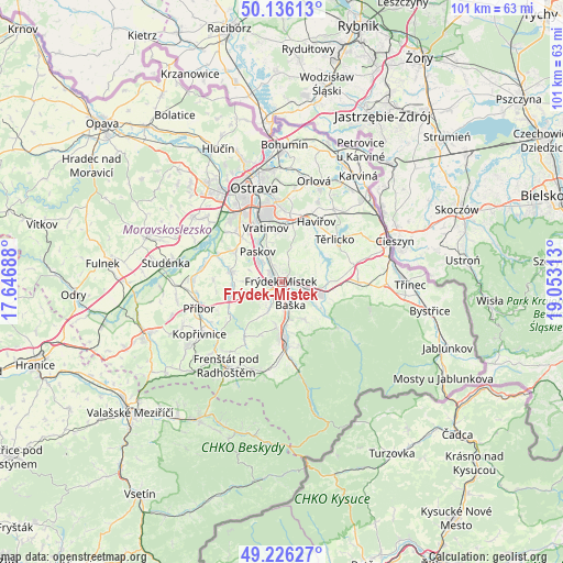
Frýdek-Místek GPS coordinates[2]
49° 40' 59.988" North, 18° 21' 0" East
| Map corner | latitude | longitude |
|---|---|---|
| Upper-left | 50.13613°, | 17.64688° |
| Center: | 49.68333°, | 18.35° |
| Lower-right: | 49.22627°, | 19.05313° |
| Map W x H: | 101.2×101.2 km | = 62.9×62.9mi |
| max Lat: | 51.01104° ⇑54.8% North |
| Frýdek-Místek: | 49.68333° |
| min Lat: | ⇓45.2% South 48.60378° |
| min Long | Frýdek-Místek | max Long |
| 12.17577° | 18.35° | 18.82683° |
| W 97.7%⇐ | ⇒2.3% E |
Elevation
Elevation of Frýdek-Místek is 283 m = 928 ft, and this is 69 m = 226 ft below average elevation for this country.
| Max E: |
901 m = 2956 ft | 62.2% |
| Avg. | 352 m = 1155 ft | |
| Frýdek-Místek | 283 m = 928 ft | |
Min E: |
136 m = 446 ft | 37.8% |
See also: Frýdek-Místek elevation on elevation.city.
Geographical zone
Frýdek-Místek is located in North temperate zone (between Tropic of Cancer and the Arctic Circle). Distance of this North polar circle is 1876.9 km =1166.3 mi to North.| Distance of | km | miles | from Frýdek-Místek |
|---|---|---|---|
| North Pole | 4482.8 | 2785.5 | to North |
| Arctic Circle | 1876.9 | 1166.3 | to North |
| Tropic Cancer | 2918.3 | 1813.3 | to South |
| Equator | 5524.3 | 3432.6 | to South |


Nearby cities:
15 places around Frýdek-Místek: (largest is in red/bold)
• Baška
4.5 km =2.8 mi,  158°
158°
• Bruzovice
5.7 km =3.5 mi,  48°
48°
• Dobrá
4.7 km =2.9 mi,  102°
102°
• Horní Domaslavice
8 km =5 mi,  80°
80°
• Janovice
8 km =5 mi,  149°
149°
• Nošovice
6 km =3.7 mi,  114°
114°
• Palkovice
6 km =3.7 mi,  204°
204°
• Paskov
6.9 km =4.3 mi,  321°
321°
• Sedliště
4.1 km =2.5 mi,  19°
19°
• Staré Město
1.8 km =1.1 mi, 146°
• Staříč
5.6 km =3.5 mi,  272°
272°
• Sviadnov
1.7 km =1.1 mi,  292°
292°
• Václavovice
8.2 km =5.1 mi,  11°
11°
• Řepiště
6 km =3.7 mi,  336°
336°
• Žabeň
4.3 km =2.7 mi,  310°
310°
Sources, notices
• [Note1] Compared only with cities in Czech Republic existing in our database
• [Src1] Map data: © OpenStreetMap contributors (CC-BY-SA)
• [Src2] Other city data from geonames.org with taken over terms of usage.
• [Src3] Geographical zone / Annual Mean Temperature by Robert A. Rohde @ Wikipedia
