Hlavňovice geodata
Hlavňovice (Plzeňský kraj) is a populated place; located in Czech Republic in Europe/Prague (GMT+2) time zone. With population of 504 people, there are 2492 cities with bigger population in this country. Compared to other cities in Czech Republic, 79.6% of cities are located further ↑North; 92.6% of cities are located further →East and 98.7% of cities have lower elevation than Hlavňovice. Note1


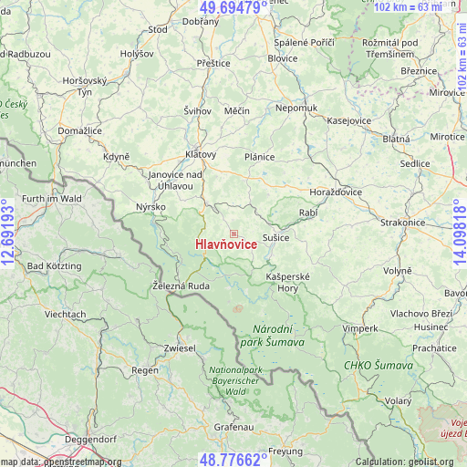
Hlavňovice GPS coordinates[2]
49° 14' 16.224" North, 13° 23' 42.18" East
| Map corner | latitude | longitude |
|---|---|---|
| Upper-left | 49.69479°, | 12.69193° |
| Center: | 49.23784°, | 13.39505° |
| Lower-right: | 48.77662°, | 14.09818° |
| Map W x H: | 102.1×102.1 km | = 63.4×63.4mi |
| max Lat: | 51.01104° ⇑79.6% North |
| Hlavňovice: | 49.23784° |
| min Lat: | ⇓20.4% South 48.60378° |
| min Long | Hlavňovice | max Long |
| 12.17577° | 13.39505° | 18.82683° |
| W 7.4%⇐ | ⇒92.6% E |
Elevation
Elevation of Hlavňovice is 691 m = 2267 ft, and this is 339 m = 1112 ft above average elevation for this country.
| Max E: |
901 m = 2956 ft | 1.3% |
| Hlavňovice | 691 m 2267 ft | |
| Avg. | 352 m = 1155 ft | |
Min E: |
136 m = 446 ft | 98.7% |
See also: Czech Republic elevation on elevation.city.
Geographical zone
Hlavňovice is located in North temperate zone (between Tropic of Cancer and the Arctic Circle). Distance of this North polar circle is 1926.4 km =1197 mi to North.| Distance of | km | miles | from Hlavňovice |
|---|---|---|---|
| North Pole | 4532.3 | 2816.2 | to North |
| Arctic Circle | 1926.4 | 1197 | to North |
| Tropic Cancer | 2868.8 | 1782.6 | to South |
| Equator | 5474.7 | 3401.8 | to South |


Nearby cities:
15 places around Hlavňovice: (largest is in red/bold)
• Běšiny
9.3 km =5.8 mi,  319°
319°
• Dešenice
16.8 km =10.4 mi,  283°
283°
• Dlouhá Ves
9.5 km =5.9 mi,  119°
119°
• Hartmanice
8.7 km =5.4 mi,  150°
150°
• Hrádek
7.9 km =4.9 mi,  70°
70°
• Kašperské Hory
15.8 km =9.8 mi,  132°
132°
• Kolinec
7.5 km =4.7 mi,  25°
25°
• Mochtín
13.9 km =8.6 mi,  348°
348°
• Strážov
13 km =8.1 mi,  303°
303°
• Sušice
9.1 km =5.7 mi,  94°
94°
• Velhartice
3.1 km =1.9 mi, 352°
• Vrhaveč
14 km =8.7 mi,  329°
329°
• Čachrov
7.4 km =4.6 mi,  294°
294°
• Železná Ruda
16.1 km =10 mi,  226°
226°
• Žichovice
17.2 km =10.7 mi,  79°
79°
Sources, notices
• [Note1] Compared only with cities in Czech Republic existing in our database
• [Src1] Map data: © OpenStreetMap contributors (CC-BY-SA)
• [Src2] Other city data from geonames.org with taken over terms of usage.
• [Src3] Geographical zone / Annual Mean Temperature by Robert A. Rohde @ Wikipedia
