Chudenice geodata
Chudenice (Plzeňský kraj) is a populated place; located in Czech Republic in Europe/Prague (GMT+2) time zone. With population of 699 people, there are 1835 cities with bigger population in this country. Compared to other cities in Czech Republic, 67.6% of cities are located further ↑North; 95% of cities are located further →East and 84.7% of cities have lower elevation than Chudenice. Note1


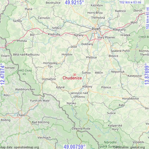
Chudenice GPS coordinates[2]
49° 28' 0.048" North, 13° 10' 25.896" East
| Map corner | latitude | longitude |
|---|---|---|
| Upper-left | 49.9215°, | 12.47074° |
| Center: | 49.46668°, | 13.17386° |
| Lower-right: | 49.00759°, | 13.87699° |
| Map W x H: | 101.6×101.6 km | = 63.1×63.1mi |
| max Lat: | 51.01104° ⇑67.6% North |
| Chudenice: | 49.46668° |
| min Lat: | ⇓32.4% South 48.60378° |
| min Long | Chudenice | max Long |
| 12.17577° | 13.17386° | 18.82683° |
| W 5%⇐ | ⇒95% E |
Elevation
Elevation of Chudenice is 492 m = 1614 ft, and this is 140 m = 459 ft above average elevation for this country.
| Max E: |
901 m = 2956 ft | 15.3% |
| Chudenice | 492 m 1614 ft | |
| Avg. | 352 m = 1155 ft | |
Min E: |
136 m = 446 ft | 84.7% |
See also: Czech Republic elevation on elevation.city.
Geographical zone
Chudenice is located in North temperate zone (between Tropic of Cancer and the Arctic Circle). Distance of this North polar circle is 1901 km =1181.2 mi to North.| Distance of | km | miles | from Chudenice |
|---|---|---|---|
| North Pole | 4506.9 | 2800.5 | to North |
| Arctic Circle | 1901 | 1181.2 | to North |
| Tropic Cancer | 2894.3 | 1798.4 | to South |
| Equator | 5500.2 | 3417.7 | to South |


Nearby cities:
15 places around Chudenice: (largest is in red/bold)
• Bezděkov
10.3 km =6.4 mi,  157°
157°
• Blížejov
13.8 km =8.6 mi,  285°
285°
• Dolany
6 km =3.7 mi,  115°
115°
• Janovice nad Úhlavou
13.9 km =8.6 mi,  166°
166°
• Kdyně
12.9 km =8 mi,  228°
228°
• Klatovy
11.8 km =7.3 mi,  132°
132°
• Koloveč
5.2 km =3.2 mi,  295°
295°
• Lužany
13.6 km =8.5 mi,  49°
49°
• Merklín
10.6 km =6.6 mi,  9°
9°
• Osvračín
10.5 km =6.5 mi, 299°
• Předslav
13.2 km =8.2 mi,  99°
99°
• Soběkury
13.1 km =8.1 mi,  21°
21°
• Staňkov
12.2 km =7.6 mi,  322°
322°
• Zahořany
12.9 km =8 mi,  253°
253°
• Švihov
8.1 km =5 mi,  78°
78°
Sources, notices
• [Note1] Compared only with cities in Czech Republic existing in our database
• [Src1] Map data: © OpenStreetMap contributors (CC-BY-SA)
• [Src2] Other city data from geonames.org with taken over terms of usage.
• [Src3] Geographical zone / Annual Mean Temperature by Robert A. Rohde @ Wikipedia
