Zaberfeld geodata
Zaberfeld (Baden-Württemberg) is a seat of a fourth-order administrative division; located in Germany in Europe/Berlin (GMT+2) time zone. With population of 3,843 people, there are 3383 cities with bigger population in this country. Compared to other cities in Germany, 82.3% of cities are located further ↑North; 66.3% of cities are located further →East and 51.6% of cities have lower elevation than Zaberfeld. Note1
Administrative division(s):
- Level 1: Baden-Württemberg
- Level 2: Regierungsbezirk Stuttgart
- Level 3: Landkreis Heilbronn
- Level 4: Zaberfeld


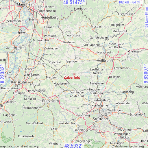
Zaberfeld GPS coordinates[2]
49° 3' 21.996" North, 8° 55' 36.984" East
| Map corner | latitude | longitude |
|---|---|---|
| Upper-left | 49.51475°, | 8.22382° |
| Center: | 49.05611°, | 8.92694° |
| Lower-right: | 48.5932°, | 9.63007° |
| Map W x H: | 102.5×102.5 km | = 63.7×63.7mi |
| max Lat: | 55.01917° ⇑82.3% North |
| Zaberfeld: | 49.05611° |
| min Lat: | ⇓17.7% South 47.40724° |
| min Long | Zaberfeld | max Long |
| 5.92978° | 8.92694° | 14.98853° |
| W 33.7%⇐ | ⇒66.3% E |
Elevation
Elevation of Zaberfeld is 237 m = 778 ft, and this is 12.1 m = 40 ft below average elevation for this country.
| Max E: |
1256 m = 4121 ft | 48.4% |
| Avg. | 249.1 m = 817 ft | |
| Zaberfeld | 237 m = 778 ft | |
Min E: |
-5 m = -16 ft | 51.6% |
See also: Germany elevation on elevation.city.
Geographical zone
Zaberfeld is located in North temperate zone (between Tropic of Cancer and the Arctic Circle). Distance of this North polar circle is 1946.6 km =1209.6 mi to North.| Distance of | km | miles | from Zaberfeld |
|---|---|---|---|
| North Pole | 4552.5 | 2828.8 | to North |
| Arctic Circle | 1946.6 | 1209.6 | to North |
| Tropic Cancer | 2848.6 | 1770 | to South |
| Equator | 5454.5 | 3389.3 | to South |


Nearby cities:
15 places around Zaberfeld: (largest is in red/bold)
• Brackenheim
10.4 km =6.5 mi,  76°
76°
• Cleebronn
8.1 km =5 mi,  98°
98°
• Eppingen
9 km =5.6 mi,  353°
353°
• Freudental
10.9 km =6.8 mi,  118°
118°
• Gemmingen
11.8 km =7.3 mi,  19°
19°
• Güglingen
5.6 km =3.5 mi, 78°
• Illingen
11.1 km =6.9 mi,  180°
180°
• Kürnbach
6.4 km =4 mi,  291°
291°
• Maulbronn
11 km =6.8 mi,  235°
235°
• Oberderdingen
9.1 km =5.7 mi,  276°
276°
• Pfaffenhofen
3.7 km =2.3 mi, 75°
• Sersheim
11.9 km =7.4 mi,  146°
146°
• Sternenfels
5.6 km =3.5 mi,  264°
264°
• Sulzfeld
7.5 km =4.7 mi,  316°
316°
• Zaisenhausen
10 km =6.2 mi,  304°
304°
Sources, notices
• [Note1] Compared only with cities in Germany existing in our database
• [Src1] Map data: © OpenStreetMap contributors (CC-BY-SA)
• [Src2] Other city data from geonames.org with taken over terms of usage.
• [Src3] Geographical zone / Annual Mean Temperature by Robert A. Rohde @ Wikipedia
