Kürnbach geodata
Kürnbach (Baden-Württemberg) is a seat of a fourth-order administrative division; located in Germany in Europe/Berlin (GMT+2) time zone. With population of 2,440 people, there are 4514 cities with bigger population in this country. Compared to other cities in Germany, 82% of cities are located further ↑North; 67.4% of cities are located further →East and 53.8% of cities have higher elevation than Kürnbach. Note1
Administrative division(s):
- Level 1: Baden-Württemberg
- Level 2: Karlsruhe Region
- Level 3: Landkreis Karlsruhe
- Level 4: Kürnbach


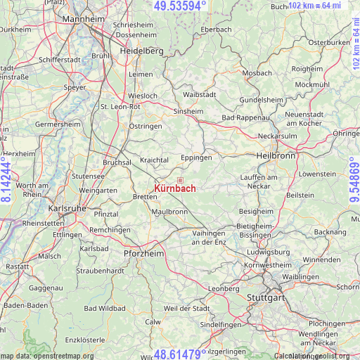
Kürnbach GPS coordinates[2]
49° 4' 39" North, 8° 50' 44.016" East
| Map corner | latitude | longitude |
|---|---|---|
| Upper-left | 49.53594°, | 8.14244° |
| Center: | 49.0775°, | 8.84556° |
| Lower-right: | 48.61479°, | 9.54869° |
| Map W x H: | 102.4×102.4 km | = 63.6×63.6mi |
| max Lat: | 55.01917° ⇑82% North |
| Kürnbach: | 49.0775° |
| min Lat: | ⇓18% South 47.40724° |
| min Long | Kürnbach | max Long |
| 5.92978° | 8.84556° | 14.98853° |
| W 32.6%⇐ | ⇒67.4% E |
Elevation
Elevation of Kürnbach is 198 m = 650 ft, and this is 51.1 m = 168 ft below average elevation for this country.
| Max E: |
1256 m = 4121 ft | 53.8% |
| Avg. | 249.1 m = 817 ft | |
| Kürnbach | 198 m = 650 ft | |
Min E: |
-5 m = -16 ft | 46.2% |
See also: Germany elevation on elevation.city.
Geographical zone
Kürnbach is located in North temperate zone (between Tropic of Cancer and the Arctic Circle). Distance of this North polar circle is 1944.3 km =1208.1 mi to North.| Distance of | km | miles | from Kürnbach |
|---|---|---|---|
| North Pole | 4550.2 | 2827.4 | to North |
| Arctic Circle | 1944.3 | 1208.1 | to North |
| Tropic Cancer | 2851 | 1771.5 | to South |
| Equator | 5456.9 | 3390.8 | to South |


Nearby cities:
15 places around Kürnbach: (largest is in red/bold)
• Bretten
11 km =6.8 mi,  245°
245°
• Eppingen
8.2 km =5.1 mi,  36°
36°
• Gemmingen
13.2 km =8.2 mi,  48°
48°
• Gondelsheim
13.8 km =8.6 mi,  261°
261°
• Güglingen
11.4 km =7.1 mi,  96°
96°
• Knittlingen
8.8 km =5.5 mi,  228°
228°
• Kraichtal
11.2 km =7 mi,  312°
312°
• Maulbronn
9.2 km =5.7 mi,  199°
199°
• Oberderdingen
3.4 km =2.1 mi, 246°
• Pfaffenhofen
9.6 km =6 mi, 98°
• Sternenfels
2.9 km =1.8 mi,  172°
172°
• Sulzfeld
3.1 km =1.9 mi,  13°
13°
• Zaberfeld
6.4 km =4 mi,  111°
111°
• Zaisenhausen
4 km =2.5 mi,  323°
323°
• Ötisheim
12.8 km =8 mi, 195°
Sources, notices
• [Note1] Compared only with cities in Germany existing in our database
• [Src1] Map data: © OpenStreetMap contributors (CC-BY-SA)
• [Src2] Other city data from geonames.org with taken over terms of usage.
• [Src3] Geographical zone / Annual Mean Temperature by Robert A. Rohde @ Wikipedia
