Wollershausen geodata
Wollershausen (Lower Saxony) is a seat of a fourth-order administrative division; located in Germany in Europe/Berlin (GMT+2) time zone. With population of 489 people, there are 9418 cities with bigger population in this country. Compared to other cities in Germany, 67.6% of cities are located further ↓South; 54.3% of cities are located further ←West and 59.8% of cities have higher elevation than Wollershausen. Note1
Administrative division(s):
- Level 1: Lower Saxony
- Level 3: Landkreis Göttingen
- Level 4: Wollershausen


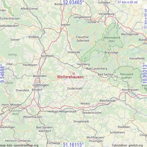
Wollershausen GPS coordinates[2]
51° 36' 0" North, 10° 15' 0" East
| Map corner | latitude | longitude |
|---|---|---|
| Upper-left | 52.03465°, | 9.54688° |
| Center: | 51.6°, | 10.25° |
| Lower-right: | 51.16115°, | 10.95313° |
| Map W x H: | 97.1×97.1 km | = 60.3×60.3mi |
| max Lat: | 55.01917° ⇑32.4% North |
| Wollershausen: | 51.6° |
| min Lat: | ⇓67.6% South 47.40724° |
| min Long | Wollershausen | max Long |
| 5.92978° | 10.25° | 14.98853° |
| W 54.3%⇐ | ⇒45.7% E |
Elevation
Elevation of Wollershausen is 154 m = 505 ft, and this is 95.1 m = 312 ft below average elevation for this country.
| Max E: |
1256 m = 4121 ft | 59.8% |
| Avg. | 249.1 m = 817 ft | |
| Wollershausen | 154 m = 505 ft | |
Min E: |
-5 m = -16 ft | 40.2% |
See also: Germany elevation on elevation.city.
Geographical zone
Wollershausen is located in North temperate zone (between Tropic of Cancer and the Arctic Circle). Distance of this North polar circle is 1663.8 km =1033.8 mi to North.| Distance of | km | miles | from Wollershausen |
|---|---|---|---|
| North Pole | 4269.7 | 2653.1 | to North |
| Arctic Circle | 1663.8 | 1033.8 | to North |
| Tropic Cancer | 3131.5 | 1945.8 | to South |
| Equator | 5737.4 | 3565.1 | to South |


Nearby cities:
15 places around Wollershausen: (largest is in red/bold)
• Bilshausen
7.1 km =4.4 mi,  297°
297°
• Bodensee
8.1 km =5 mi,  274°
274°
• Elbingerode
6.9 km =4.3 mi,  16°
16°
• Gieboldehausen
2.6 km =1.6 mi,  294°
294°
• Hattorf
5.7 km =3.5 mi,  350°
350°
• Herzberg am Harz
8.7 km =5.4 mi,  45°
45°
• Hörden
7.9 km =4.9 mi, 17°
• Obernfeld
5.7 km =3.5 mi,  191°
191°
• Rhumspringe
3.9 km =2.4 mi,  118°
118°
• Rollshausen
4.4 km =2.7 mi,  211°
211°
• Rüdershausen
2.2 km =1.4 mi,  148°
148°
• Seeburg
7.8 km =4.8 mi,  241°
241°
• Seulingen
8.9 km =5.5 mi,  222°
222°
• Wollbrandshausen
6 km =3.7 mi,  252°
252°
• Wulften
8.5 km =5.3 mi,  321°
321°
Sources, notices
• [Note1] Compared only with cities in Germany existing in our database
• [Src1] Map data: © OpenStreetMap contributors (CC-BY-SA)
• [Src2] Other city data from geonames.org with taken over terms of usage.
• [Src3] Geographical zone / Annual Mean Temperature by Robert A. Rohde @ Wikipedia
