Wolgast geodata
Wolgast (Mecklenburg-Vorpommern) is a populated place; located in Germany in Europe/Berlin (GMT+2) time zone. With population of 12,664 people, there are 1277 cities with bigger population in this country. Compared to other cities in Germany, 93.4% of cities are located further ↓South; 97.2% of cities are located further ←West and 92% of cities have higher elevation than Wolgast. Note1
Administrative division(s):
- Level 1: Mecklenburg-Vorpommern
- Level 3: Vorpommern-Greifswald
- Level 4: Wolgast


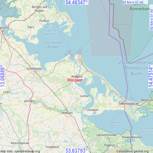
Wolgast GPS coordinates[2]
54° 3' 9.9" North, 13° 46' 19.236" East
| Map corner | latitude | longitude |
|---|---|---|
| Upper-left | 54.46347°, | 13.06889° |
| Center: | 54.05275°, | 13.77201° |
| Lower-right: | 53.63793°, | 14.47514° |
| Map W x H: | 91.8×91.8 km | = 57×57mi |
| max Lat: | 55.01917° ⇑6.6% North |
| Wolgast: | 54.05275° |
| min Lat: | ⇓93.4% South 47.40724° |
| min Long | Wolgast | max Long |
| 5.92978° | 13.77201° | 14.98853° |
| W 97.2%⇐ | ⇒2.8% E |
Elevation
Elevation of Wolgast is 16 m = 52 ft, and this is 233.1 m = 765 ft below average elevation for this country.
| Max E: |
1256 m = 4121 ft | 92% |
| Avg. | 249.1 m = 817 ft | |
| Wolgast | 16 m = 52 ft | |
Min E: |
-5 m = -16 ft | 8% |
See also: Germany elevation on elevation.city.
Geographical zone
Wolgast is located in North temperate zone (between Tropic of Cancer and the Arctic Circle). Distance of this North polar circle is 1391.1 km =864.4 mi to North.| Distance of | km | miles | from Wolgast |
|---|---|---|---|
| North Pole | 3997 | 2483.6 | to North |
| Arctic Circle | 1391.1 | 864.4 | to North |
| Tropic Cancer | 3404.2 | 2115.3 | to South |
| Equator | 6010.1 | 3734.5 | to South |


Nearby cities:
15 places around Wolgast: (largest is in red/bold)
• Hohendorf
3.8 km =2.4 mi,  225°
225°
• Karlshagen
7.6 km =4.7 mi,  31°
31°
• Katzow
6.2 km =3.9 mi,  264°
264°
• Kröslin
7.2 km =4.5 mi,  348°
348°
• Lassan
12.7 km =7.9 mi,  155°
155°
• Lubmin
13.6 km =8.5 mi,  312°
312°
• Lühmannsdorf
10.2 km =6.3 mi,  241°
241°
• Mölschow
4.8 km =3 mi,  55°
55°
• Neu Boltenhagen
10.7 km =6.6 mi,  278°
278°
• Ostseebad Zinnowitz
9.5 km =5.9 mi,  73°
73°
• Rubkow
13.5 km =8.4 mi,  193°
193°
• Trassenheide
7 km =4.3 mi, 59°
• Wusterhusen
12.2 km =7.6 mi,  303°
303°
• Zemitz
8.3 km =5.2 mi, 187°
• Zempin
12 km =7.5 mi,  84°
84°
Sources, notices
• [Note1] Compared only with cities in Germany existing in our database
• [Src1] Map data: © OpenStreetMap contributors (CC-BY-SA)
• [Src2] Other city data from geonames.org with taken over terms of usage.
• [Src3] Geographical zone / Annual Mean Temperature by Robert A. Rohde @ Wikipedia
