Wanzleben geodata
Wanzleben (Saxony-Anhalt) is a populated place; located in Germany in Europe/Berlin (GMT+2) time zone. With population of 5,397 people, there are 2666 cities with bigger population in this country. Compared to other cities in Germany, 72.6% of cities are located further ↓South; 73.3% of cities are located further ←West and 69% of cities have higher elevation than Wanzleben. Note1


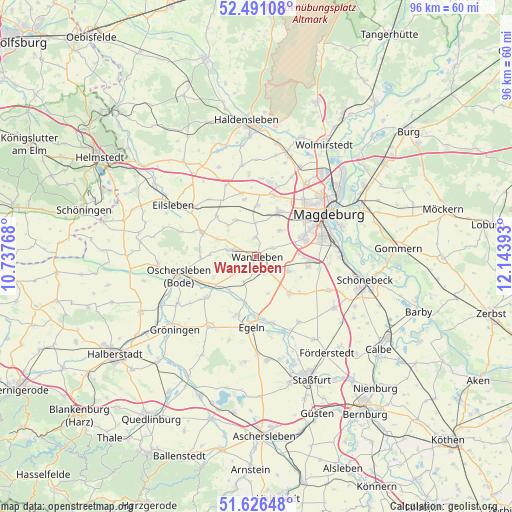
Wanzleben GPS coordinates[2]
52° 3' 39.132" North, 11° 26' 26.88" East
| Map corner | latitude | longitude |
|---|---|---|
| Upper-left | 52.49108°, | 10.73768° |
| Center: | 52.06087°, | 11.4408° |
| Lower-right: | 51.62648°, | 12.14393° |
| Map W x H: | 96.1×96.1 km | = 59.7×59.7mi |
| max Lat: | 55.01917° ⇑27.4% North |
| Wanzleben: | 52.06087° |
| min Lat: | ⇓72.6% South 47.40724° |
| min Long | Wanzleben | max Long |
| 5.92978° | 11.4408° | 14.98853° |
| W 73.3%⇐ | ⇒26.7% E |
Elevation
Elevation of Wanzleben is 97 m = 318 ft, and this is 152.1 m = 499 ft below average elevation for this country.
| Max E: |
1256 m = 4121 ft | 69% |
| Avg. | 249.1 m = 817 ft | |
| Wanzleben | 97 m = 318 ft | |
Min E: |
-5 m = -16 ft | 31% |
See also: Germany elevation on elevation.city.
Geographical zone
Wanzleben is located in North temperate zone (between Tropic of Cancer and the Arctic Circle). Distance of this North polar circle is 1612.5 km =1002 mi to North.| Distance of | km | miles | from Wanzleben |
|---|---|---|---|
| North Pole | 4218.4 | 2621.2 | to North |
| Arctic Circle | 1612.5 | 1002 | to North |
| Tropic Cancer | 3182.7 | 1977.6 | to South |
| Equator | 5788.6 | 3596.9 | to South |


Nearby cities:
15 places around Wanzleben: (largest is in red/bold)
• Bottmersdorf
3.5 km =2.2 mi,  193°
193°
• Diesdorf
11.5 km =7.1 mi,  47°
47°
• Domersleben
3.5 km =2.2 mi,  356°
356°
• Dreileben
10.6 km =6.6 mi,  315°
315°
• Etgersleben
9.3 km =5.8 mi, 191°
• Groß Rodensleben
7.8 km =4.8 mi,  329°
329°
• Hohendodeleben
6.5 km =4 mi,  42°
42°
• Klein Rodensleben
6.1 km =3.8 mi, 358°
• Klein Wanzleben
5.2 km =3.2 mi,  281°
281°
• Niederndodeleben
9.1 km =5.7 mi,  26°
26°
• Ochtmersleben
11 km =6.8 mi,  348°
348°
• Schermcke
10.5 km =6.5 mi,  267°
267°
• Seehausen
11.2 km =7 mi,  294°
294°
• Wellen
9.4 km =5.8 mi,  0°
0°
• Westeregeln
11.3 km =7 mi,  196°
196°
Sources, notices
• [Note1] Compared only with cities in Germany existing in our database
• [Src1] Map data: © OpenStreetMap contributors (CC-BY-SA)
• [Src2] Other city data from geonames.org with taken over terms of usage.
• [Src3] Geographical zone / Annual Mean Temperature by Robert A. Rohde @ Wikipedia
