Wangelau geodata
Wangelau (Schleswig-Holstein) is a seat of a fourth-order administrative division; located in Germany in Europe/Berlin (GMT+2) time zone. With population of 231 people, there are 10344 cities with bigger population in this country. Compared to other cities in Germany, 85% of cities are located further ↓South; 59.8% of cities are located further ←West and 84.5% of cities have higher elevation than Wangelau. Note1
Administrative division(s):
- Level 1: Schleswig-Holstein
- Level 3: Kreis Herzogtum Lauenburg
- Level 4: Wangelau


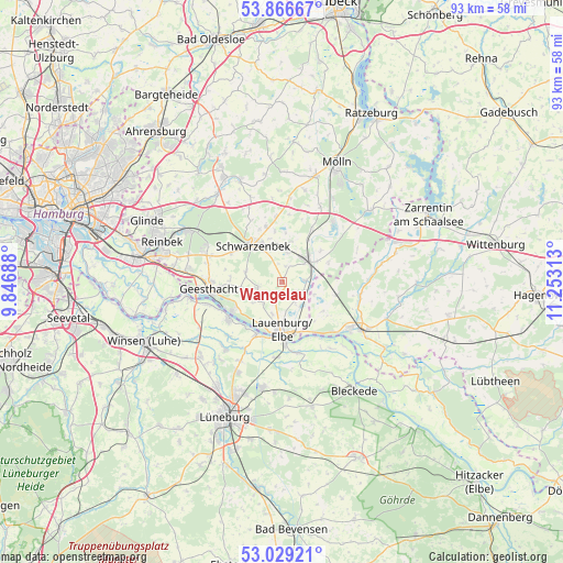
Wangelau GPS coordinates[2]
53° 27' 0" North, 10° 33' 0" East
| Map corner | latitude | longitude |
|---|---|---|
| Upper-left | 53.86667°, | 9.84688° |
| Center: | 53.45°, | 10.55° |
| Lower-right: | 53.02921°, | 11.25313° |
| Map W x H: | 93.1×93.1 km | = 57.8×57.8mi |
| max Lat: | 55.01917° ⇑15% North |
| Wangelau: | 53.45° |
| min Lat: | ⇓85% South 47.40724° |
| min Long | Wangelau | max Long |
| 5.92978° | 10.55° | 14.98853° |
| W 59.8%⇐ | ⇒40.2% E |
Elevation
Elevation of Wangelau is 36 m = 118 ft, and this is 213.1 m = 699 ft below average elevation for this country.
| Max E: |
1256 m = 4121 ft | 84.5% |
| Avg. | 249.1 m = 817 ft | |
| Wangelau | 36 m = 118 ft | |
Min E: |
-5 m = -16 ft | 15.5% |
See also: Germany elevation on elevation.city.
Geographical zone
Wangelau is located in North temperate zone (between Tropic of Cancer and the Arctic Circle). Distance of this North polar circle is 1458.1 km =906 mi to North.| Distance of | km | miles | from Wangelau |
|---|---|---|---|
| North Pole | 4064 | 2525.3 | to North |
| Arctic Circle | 1458.1 | 906 | to North |
| Tropic Cancer | 3337.2 | 2073.6 | to South |
| Equator | 5943.1 | 3692.9 | to South |


Nearby cities:
15 places around Wangelau: (largest is in red/bold)
• Basedow
4.3 km =2.7 mi,  149°
149°
• Buchhorst
7.2 km =4.5 mi,  171°
171°
• Büchen
5.6 km =3.5 mi,  53°
53°
• Dalldorf
4.4 km =2.7 mi,  112°
112°
• Grabau
7.3 km =4.5 mi,  344°
344°
• Gülzow
3.3 km =2.1 mi,  270°
270°
• Juliusburg
5 km =3.1 mi,  221°
221°
• Kollow
5.8 km =3.6 mi,  288°
288°
• Krukow
5.8 km =3.6 mi,  229°
229°
• Krüzen
5.7 km =3.5 mi,  191°
191°
• Lütau
1.9 km =1.2 mi,  180°
180°
• Müssen
4.8 km =3 mi,  11°
11°
• Schulendorf
2.7 km =1.7 mi,  15°
15°
• Wiershop
6.9 km =4.3 mi,  254°
254°
• Witzeeze
3.8 km =2.4 mi,  87°
87°
Sources, notices
• [Note1] Compared only with cities in Germany existing in our database
• [Src1] Map data: © OpenStreetMap contributors (CC-BY-SA)
• [Src2] Other city data from geonames.org with taken over terms of usage.
• [Src3] Geographical zone / Annual Mean Temperature by Robert A. Rohde @ Wikipedia
