Witzeeze geodata
Witzeeze (Schleswig-Holstein) is a seat of a fourth-order administrative division; located in Germany in Europe/Berlin (GMT+2) time zone. With population of 936 people, there are 7401 cities with bigger population in this country. Compared to other cities in Germany, 85% of cities are located further ↓South; 61% of cities are located further ←West and 91.6% of cities have higher elevation than Witzeeze. Note1
Administrative division(s):
- Level 1: Schleswig-Holstein
- Level 3: Kreis Herzogtum Lauenburg
- Level 4: Witzeeze


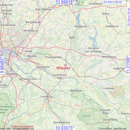
Witzeeze GPS coordinates[2]
53° 27' 5.508" North, 10° 36' 28.656" East
| Map corner | latitude | longitude |
|---|---|---|
| Upper-left | 53.86818°, | 9.90483° |
| Center: | 53.45153°, | 10.60796° |
| Lower-right: | 53.03075°, | 11.31109° |
| Map W x H: | 93.1×93.1 km | = 57.8×57.8mi |
| max Lat: | 55.01917° ⇑15% North |
| Witzeeze: | 53.45153° |
| min Lat: | ⇓85% South 47.40724° |
| min Long | Witzeeze | max Long |
| 5.92978° | 10.60796° | 14.98853° |
| W 61%⇐ | ⇒39% E |
Elevation
Elevation of Witzeeze is 17 m = 56 ft, and this is 232.1 m = 761 ft below average elevation for this country.
| Max E: |
1256 m = 4121 ft | 91.6% |
| Avg. | 249.1 m = 817 ft | |
| Witzeeze | 17 m = 56 ft | |
Min E: |
-5 m = -16 ft | 8.4% |
See also: Germany elevation on elevation.city.
Geographical zone
Witzeeze is located in North temperate zone (between Tropic of Cancer and the Arctic Circle). Distance of this North polar circle is 1457.9 km =905.9 mi to North.| Distance of | km | miles | from Witzeeze |
|---|---|---|---|
| North Pole | 4063.8 | 2525.1 | to North |
| Arctic Circle | 1457.9 | 905.9 | to North |
| Tropic Cancer | 3337.3 | 2073.7 | to South |
| Equator | 5943.3 | 3693 | to South |


Nearby cities:
15 places around Witzeeze: (largest is in red/bold)
• Basedow
4.2 km =2.6 mi,  202°
202°
• Bröthen
5 km =3.1 mi,  51°
51°
• Büchen
3.2 km =2 mi,  11°
11°
• Dalldorf
1.9 km =1.2 mi,  172°
172°
• Fitzen
5.5 km =3.4 mi,  27°
27°
• Gülzow
7.2 km =4.5 mi,  268°
268°
• Klein Pampau
6.9 km =4.3 mi,  349°
349°
• Lanze
7.2 km =4.5 mi,  181°
181°
• Lütau
4.3 km =2.7 mi,  242°
242°
• Müssen
5.4 km =3.4 mi,  327°
327°
• Nostorf
5.9 km =3.7 mi,  148°
148°
• Schulendorf
3.9 km =2.4 mi,  307°
307°
• Schwanheide
5.6 km =3.5 mi,  116°
116°
• Siebeneichen
6.6 km =4.1 mi, 5°
• Wangelau
3.8 km =2.4 mi, 267°
Sources, notices
• [Note1] Compared only with cities in Germany existing in our database
• [Src1] Map data: © OpenStreetMap contributors (CC-BY-SA)
• [Src2] Other city data from geonames.org with taken over terms of usage.
• [Src3] Geographical zone / Annual Mean Temperature by Robert A. Rohde @ Wikipedia
