Vippachedelhausen geodata
Vippachedelhausen (Thuringia) is a seat of a fourth-order administrative division; located in Germany in Europe/Berlin (GMT+2) time zone. With population of 631 people, there are 8646 cities with bigger population in this country. Compared to other cities in Germany, 59.5% of cities are located further ↓South; 70.1% of cities are located further ←West and 55.5% of cities have higher elevation than Vippachedelhausen. Note1


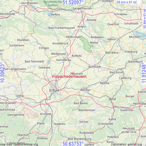
Vippachedelhausen GPS coordinates[2]
51° 4' 52.896" North, 11° 12' 33.66" East
| Map corner | latitude | longitude |
|---|---|---|
| Upper-left | 51.52097°, | 10.50623° |
| Center: | 51.08136°, | 11.20935° |
| Lower-right: | 50.63753°, | 11.91248° |
| Map W x H: | 98.2×98.2 km | = 61×61mi |
| max Lat: | 55.01917° ⇑40.5% North |
| Vippachedelhausen: | 51.08136° |
| min Lat: | ⇓59.5% South 47.40724° |
| min Long | Vippachedelhaus | max Long |
| 5.92978° | 11.20935° | 14.98853° |
| W 70.1%⇐ | ⇒29.9% E |
Elevation
Elevation of Vippachedelhausen is 185 m = 607 ft, and this is 64.1 m = 210 ft below average elevation for this country.
| Max E: |
1256 m = 4121 ft | 55.5% |
| Avg. | 249.1 m = 817 ft | |
| Vippachedelhausen | 185 m = 607 ft | |
Min E: |
-5 m = -16 ft | 44.5% |
See also: Germany elevation on elevation.city.
Geographical zone
Vippachedelhausen is located in North temperate zone (between Tropic of Cancer and the Arctic Circle). Distance of this North polar circle is 1721.5 km =1069.7 mi to North.| Distance of | km | miles | from Vippachedelhausen |
|---|---|---|---|
| North Pole | 4327.3 | 2688.9 | to North |
| Arctic Circle | 1721.5 | 1069.7 | to North |
| Tropic Cancer | 3073.8 | 1910 | to South |
| Equator | 5679.7 | 3529.2 | to South |


Nearby cities:
15 places around Vippachedelhausen: (largest is in red/bold)
• Ballstedt
3.5 km =2.2 mi,  171°
171°
• Berlstedt
3.2 km =2 mi,  133°
133°
• Eckstedt
4.6 km =2.9 mi,  255°
255°
• Ettersburg
7.2 km =4.5 mi,  137°
137°
• Großmölsen
7.5 km =4.7 mi,  224°
224°
• Kleinbrembach
7 km =4.3 mi,  34°
34°
• Krautheim
6.3 km =3.9 mi,  88°
88°
• Markvippach
2.4 km =1.5 mi, 263°
• Ollendorf
5.6 km =3.5 mi,  198°
198°
• Ramsla
6.2 km =3.9 mi,  124°
124°
• Schloßvippach
5.2 km =3.2 mi,  300°
300°
• Schwerstedt
5.4 km =3.4 mi,  107°
107°
• Sprötau
4.9 km =3 mi,  349°
349°
• Udestedt
6.4 km =4 mi,  236°
236°
• Vogelsberg
6.4 km =4 mi, 26°
Sources, notices
• [Note1] Compared only with cities in Germany existing in our database
• [Src1] Map data: © OpenStreetMap contributors (CC-BY-SA)
• [Src2] Other city data from geonames.org with taken over terms of usage.
• [Src3] Geographical zone / Annual Mean Temperature by Robert A. Rohde @ Wikipedia
