Vogelsberg geodata
Vogelsberg (Thuringia) is a seat of a fourth-order administrative division; located in Germany in Europe/Berlin (GMT+2) time zone. With population of 759 people, there are 8052 cities with bigger population in this country. Compared to other cities in Germany, 60.4% of cities are located further ↓South; 70.6% of cities are located further ←West and 59.3% of cities have higher elevation than Vogelsberg. Note1


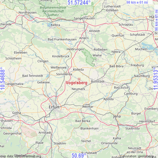
Vogelsberg GPS coordinates[2]
51° 7' 59.988" North, 11° 15' 0" East
| Map corner | latitude | longitude |
|---|---|---|
| Upper-left | 51.57244°, | 10.54688° |
| Center: | 51.13333°, | 11.25° |
| Lower-right: | 50.69°, | 11.95313° |
| Map W x H: | 98.1×98.1 km | = 61×61mi |
| max Lat: | 55.01917° ⇑39.6% North |
| Vogelsberg: | 51.13333° |
| min Lat: | ⇓60.4% South 47.40724° |
| min Long | Vogelsberg | max Long |
| 5.92978° | 11.25° | 14.98853° |
| W 70.6%⇐ | ⇒29.4% E |
Elevation
Elevation of Vogelsberg is 158 m = 518 ft, and this is 91.1 m = 299 ft below average elevation for this country.
| Max E: |
1256 m = 4121 ft | 59.3% |
| Avg. | 249.1 m = 817 ft | |
| Vogelsberg | 158 m = 518 ft | |
Min E: |
-5 m = -16 ft | 40.7% |
See also: Germany elevation on elevation.city.
Geographical zone
Vogelsberg is located in North temperate zone (between Tropic of Cancer and the Arctic Circle). Distance of this North polar circle is 1715.7 km =1066.1 mi to North.| Distance of | km | miles | from Vogelsberg |
|---|---|---|---|
| North Pole | 4321.6 | 2685.3 | to North |
| Arctic Circle | 1715.7 | 1066.1 | to North |
| Tropic Cancer | 3079.6 | 1913.6 | to South |
| Equator | 5685.5 | 3532.8 | to South |


Nearby cities:
15 places around Vogelsberg: (largest is in red/bold)
• Berlstedt
8 km =5 mi,  183°
183°
• Ellersleben
5 km =3.1 mi,  68°
68°
• Großbrembach
5 km =3.1 mi,  111°
111°
• Großneuhausen
3.9 km =2.4 mi,  39°
39°
• Guthmannshausen
8.1 km =5 mi,  90°
90°
• Kleinbrembach
1.2 km =0.7 mi, 90°
• Kleinneuhausen
3 km =1.9 mi,  51°
51°
• Krautheim
6.6 km =4.1 mi,  147°
147°
• Kölleda
6 km =3.7 mi,  356°
356°
• Markvippach
8 km =5 mi,  220°
220°
• Olbersleben
6.1 km =3.8 mi, 72°
• Schloßvippach
8 km =5 mi,  246°
246°
• Schwerstedt
7.8 km =4.8 mi,  162°
162°
• Sprötau
3.9 km =2.4 mi,  255°
255°
• Vippachedelhausen
6.4 km =4 mi,  206°
206°
Sources, notices
• [Note1] Compared only with cities in Germany existing in our database
• [Src1] Map data: © OpenStreetMap contributors (CC-BY-SA)
• [Src2] Other city data from geonames.org with taken over terms of usage.
• [Src3] Geographical zone / Annual Mean Temperature by Robert A. Rohde @ Wikipedia
