Vielank geodata
Vielank (Mecklenburg-Vorpommern) is a populated place; located in Germany in Europe/Berlin (GMT+2) time zone. With population of 714 people, there are 8257 cities with bigger population in this country. Compared to other cities in Germany, 83.2% of cities are located further ↓South; 69% of cities are located further ←West and 92.3% of cities have higher elevation than Vielank. Note1
Administrative division(s):
- Level 1: Mecklenburg-Vorpommern
- Level 3: Ludwigslust-Parchim
- Level 4: Vielank


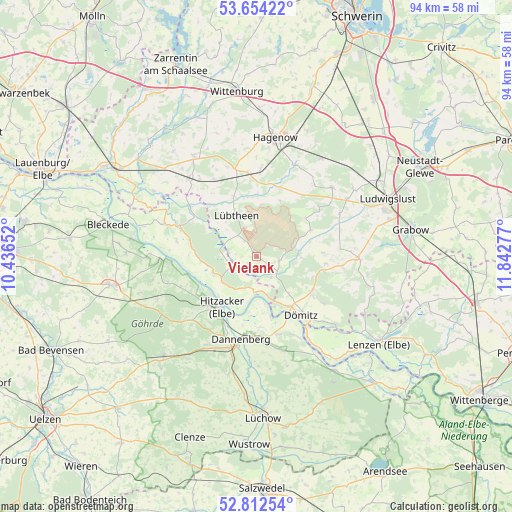
Vielank GPS coordinates[2]
53° 14' 7.62" North, 11° 8' 22.704" East
| Map corner | latitude | longitude |
|---|---|---|
| Upper-left | 53.65422°, | 10.43652° |
| Center: | 53.23545°, | 11.13964° |
| Lower-right: | 52.81254°, | 11.84277° |
| Map W x H: | 93.6×93.6 km | = 58.2×58.2mi |
| max Lat: | 55.01917° ⇑16.8% North |
| Vielank: | 53.23545° |
| min Lat: | ⇓83.2% South 47.40724° |
| min Long | Vielank | max Long |
| 5.92978° | 11.13964° | 14.98853° |
| W 69%⇐ | ⇒31% E |
Elevation
Elevation of Vielank is 15 m = 49 ft, and this is 234.1 m = 768 ft below average elevation for this country.
| Max E: |
1256 m = 4121 ft | 92.3% |
| Avg. | 249.1 m = 817 ft | |
| Vielank | 15 m = 49 ft | |
Min E: |
-5 m = -16 ft | 7.7% |
See also: Germany elevation on elevation.city.
Geographical zone
Vielank is located in North temperate zone (between Tropic of Cancer and the Arctic Circle). Distance of this North polar circle is 1481.9 km =920.8 mi to North.| Distance of | km | miles | from Vielank |
|---|---|---|---|
| North Pole | 4087.8 | 2540 | to North |
| Arctic Circle | 1481.9 | 920.8 | to North |
| Tropic Cancer | 3313.3 | 2058.8 | to South |
| Equator | 5919.2 | 3678 | to South |


Nearby cities:
15 places around Vielank: (largest is in red/bold)
• Alt Krenzlin
14.5 km =9 mi,  50°
50°
• Damnatz
11.3 km =7 mi,  167°
167°
• Dannenberg
15.8 km =9.8 mi,  192°
192°
• Dömitz
12.8 km =8 mi,  145°
145°
• Eldena
18.5 km =11.5 mi,  91°
91°
• Hitzacker
11.2 km =7 mi,  214°
214°
• Klein Gusborn
17.3 km =10.7 mi, 168°
• Kuhstorf
18.1 km =11.2 mi,  23°
23°
• Langendorf
16.8 km =10.4 mi, 152°
• Lübtheen
8.2 km =5.1 mi,  333°
333°
• Malliß
12.8 km =8 mi,  102°
102°
• Neu Darchau
16.9 km =10.5 mi,  267°
267°
• Neu Kaliß
12.3 km =7.6 mi,  123°
123°
• Pritzier
16.5 km =10.3 mi,  345°
345°
• Redefin
13.3 km =8.3 mi, 18°
Sources, notices
• [Note1] Compared only with cities in Germany existing in our database
• [Src1] Map data: © OpenStreetMap contributors (CC-BY-SA)
• [Src2] Other city data from geonames.org with taken over terms of usage.
• [Src3] Geographical zone / Annual Mean Temperature by Robert A. Rohde @ Wikipedia
