Dannenberg geodata
Dannenberg (Lower Saxony) is a populated place; located in Germany in Europe/Berlin (GMT+2) time zone. With population of 8,413 people, there are 1888 cities with bigger population in this country. Compared to other cities in Germany, 82.3% of cities are located further ↓South; 68.3% of cities are located further ←West and 92% of cities have higher elevation than Dannenberg. Note1
Administrative division(s):
- Level 1: Lower Saxony
- Level 3: Landkreis Lüchow-Dannenberg
- Level 4: Dannenberg (Elbe)


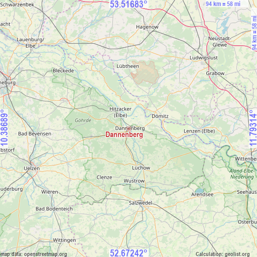
Dannenberg GPS coordinates[2]
53° 5' 48.12" North, 11° 5' 24.036" East
| Map corner | latitude | longitude |
|---|---|---|
| Upper-left | 53.51683°, | 10.38689° |
| Center: | 53.0967°, | 11.09001° |
| Lower-right: | 52.67242°, | 11.79314° |
| Map W x H: | 93.9×93.9 km | = 58.3×58.3mi |
| max Lat: | 55.01917° ⇑17.7% North |
| Dannenberg: | 53.0967° |
| min Lat: | ⇓82.3% South 47.40724° |
| min Long | Dannenberg | max Long |
| 5.92978° | 11.09001° | 14.98853° |
| W 68.3%⇐ | ⇒31.7% E |
Elevation
Elevation of Dannenberg is 16 m = 52 ft, and this is 233.1 m = 765 ft below average elevation for this country.
| Max E: |
1256 m = 4121 ft | 92% |
| Avg. | 249.1 m = 817 ft | |
| Dannenberg | 16 m = 52 ft | |
Min E: |
-5 m = -16 ft | 8% |
See also: Germany elevation on elevation.city.
Geographical zone
Dannenberg is located in North temperate zone (between Tropic of Cancer and the Arctic Circle). Distance of this North polar circle is 1497.4 km =930.4 mi to North.| Distance of | km | miles | from Dannenberg |
|---|---|---|---|
| North Pole | 4103.3 | 2549.7 | to North |
| Arctic Circle | 1497.4 | 930.4 | to North |
| Tropic Cancer | 3297.9 | 2049.2 | to South |
| Equator | 5903.8 | 3668.5 | to South |


Nearby cities:
15 places around Dannenberg: (largest is in red/bold)
• Damnatz
7.3 km =4.5 mi,  52°
52°
• Dömitz
11.8 km =7.3 mi,  65°
65°
• Göhrde
15 km =9.3 mi,  293°
293°
• Hitzacker
6.9 km =4.3 mi,  333°
333°
• Jameln
5.2 km =3.2 mi,  184°
184°
• Karwitz
5.1 km =3.2 mi,  253°
253°
• Klein Gusborn
7.1 km =4.4 mi,  102°
102°
• Küsten
13.3 km =8.3 mi,  187°
187°
• Langendorf
11.1 km =6.9 mi,  87°
87°
• Lüchow
14.9 km =9.3 mi,  163°
163°
• Neu Kaliß
16.2 km =10.1 mi,  57°
57°
• Vielank
15.8 km =9.8 mi,  12°
12°
• Waddeweitz
13.5 km =8.4 mi,  217°
217°
• Woltersdorf
18.4 km =11.4 mi,  152°
152°
• Zernien
14.2 km =8.8 mi,  257°
257°
Sources, notices
• [Note1] Compared only with cities in Germany existing in our database
• [Src1] Map data: © OpenStreetMap contributors (CC-BY-SA)
• [Src2] Other city data from geonames.org with taken over terms of usage.
• [Src3] Geographical zone / Annual Mean Temperature by Robert A. Rohde @ Wikipedia
