Unzenberg geodata
Unzenberg (Rheinland-Pfalz) is a seat of a fourth-order administrative division; located in Germany in Europe/Berlin (GMT+2) time zone. With population of 449 people, there are 9539 cities with bigger population in this country. Compared to other cities in Germany, 64.5% of cities are located further ↑North; 88.1% of cities are located further →East and 69.3% of cities have lower elevation than Unzenberg. Note1
Administrative division(s):
- Level 1: Rheinland-Pfalz
- Level 3: Rhein-Hunsrück-Kreis
- Level 4: Unzenberg


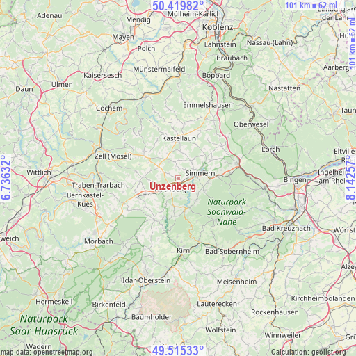
Unzenberg GPS coordinates[2]
49° 58' 10.92" North, 7° 26' 22.02" East
| Map corner | latitude | longitude |
|---|---|---|
| Upper-left | 50.41982°, | 6.73632° |
| Center: | 49.9697°, | 7.43945° |
| Lower-right: | 49.51533°, | 8.14257° |
| Map W x H: | 100.6×100.6 km | = 62.5×62.5mi |
| max Lat: | 55.01917° ⇑64.5% North |
| Unzenberg: | 49.9697° |
| min Lat: | ⇓35.5% South 47.40724° |
| min Long | Unzenberg | max Long |
| 5.92978° | 7.43945° | 14.98853° |
| W 11.9%⇐ | ⇒88.1% E |
Elevation
Elevation of Unzenberg is 353 m = 1158 ft, and this is 103.9 m = 341 ft above average elevation for this country.
| Max E: |
1256 m = 4121 ft | 30.7% |
| Unzenberg | 353 m 1158 ft | |
| Avg. | 249.1 m = 817 ft | |
Min E: |
-5 m = -16 ft | 69.3% |
See also: Germany elevation on elevation.city.
Geographical zone
Unzenberg is located in North temperate zone (between Tropic of Cancer and the Arctic Circle). Distance of this North polar circle is 1845.1 km =1146.5 mi to North.| Distance of | km | miles | from Unzenberg |
|---|---|---|---|
| North Pole | 4451 | 2765.7 | to North |
| Arctic Circle | 1845.1 | 1146.5 | to North |
| Tropic Cancer | 2950.2 | 1833.2 | to South |
| Equator | 5556.1 | 3452.4 | to South |


Nearby cities:
15 places around Unzenberg: (largest is in red/bold)
• Belgweiler
3.8 km =2.4 mi,  124°
124°
• Biebern
1.7 km =1.1 mi,  26°
26°
• Fronhofen
2.5 km =1.6 mi,  52°
52°
• Heinzenbach
1.7 km =1.1 mi,  258°
258°
• Keidelheim
4.6 km =2.9 mi,  70°
70°
• Kirchberg
3.7 km =2.3 mi,  219°
219°
• Maitzborn
4.1 km =2.5 mi,  186°
186°
• Nannhausen
3.2 km =2 mi,  96°
96°
• Ohlweiler
4.3 km =2.7 mi,  94°
94°
• Oppertshausen
2.9 km =1.8 mi,  138°
138°
• Ravengiersburg
5.1 km =3.2 mi, 142°
• Reckershausen
3.2 km =2 mi,  298°
298°
• Reich
3.4 km =2.1 mi,  352°
352°
• Rödern
2.3 km =1.4 mi,  160°
160°
• Schönborn
2.9 km =1.8 mi, 138°
Sources, notices
• [Note1] Compared only with cities in Germany existing in our database
• [Src1] Map data: © OpenStreetMap contributors (CC-BY-SA)
• [Src2] Other city data from geonames.org with taken over terms of usage.
• [Src3] Geographical zone / Annual Mean Temperature by Robert A. Rohde @ Wikipedia
