Stolberg geodata
Stolberg (North Rhine-Westphalia) is a populated place; located in Germany in Europe/Berlin (GMT+2) time zone. With population of 58,874 people, there are 180 cities with bigger population in this country. Compared to other cities in Germany, 53.7% of cities are located further ↓South; 99.6% of cities are located further →East and 55.5% of cities have higher elevation than Stolberg. Note1
Administrative division(s):
- Level 1: North Rhine-Westphalia
- Level 2: Regierungsbezirk Köln
- Level 3: Städteregion Aachen
- Level 4: Stolberg (Rhld.)


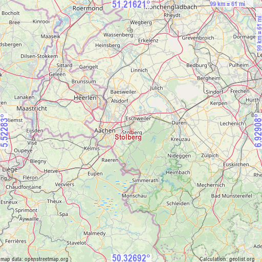
Stolberg GPS coordinates[2]
50° 46' 25.248" North, 6° 13' 33.42" East
| Map corner | latitude | longitude |
|---|---|---|
| Upper-left | 51.21621°, | 5.52283° |
| Center: | 50.77368°, | 6.22595° |
| Lower-right: | 50.32692°, | 6.92908° |
| Map W x H: | 98.9×98.9 km | = 61.5×61.5mi |
| max Lat: | 55.01917° ⇑46.3% North |
| Stolberg: | 50.77368° |
| min Lat: | ⇓53.7% South 47.40724° |
| min Long | Stolberg | max Long |
| 5.92978° | 6.22595° | 14.98853° |
| W 0.4%⇐ | ⇒99.6% E |
Elevation
Elevation of Stolberg is 185 m = 607 ft, and this is 64.1 m = 210 ft below average elevation for this country.
| Max E: |
1256 m = 4121 ft | 55.5% |
| Avg. | 249.1 m = 817 ft | |
| Stolberg | 185 m = 607 ft | |
Min E: |
-5 m = -16 ft | 44.5% |
See also: Stolberg elevation on elevation.city.
Geographical zone
Stolberg is located in North temperate zone (between Tropic of Cancer and the Arctic Circle). Distance of this North polar circle is 1755.7 km =1090.9 mi to North.| Distance of | km | miles | from Stolberg |
|---|---|---|---|
| North Pole | 4361.6 | 2710.2 | to North |
| Arctic Circle | 1755.7 | 1090.9 | to North |
| Tropic Cancer | 3039.6 | 1888.7 | to South |
| Equator | 5645.5 | 3507.9 | to South |


Nearby cities:
15 places around Stolberg: (largest is in red/bold)
• Aachen
10 km =6.2 mi,  271°
271°
• Aldenhoven
14.6 km =9.1 mi,  16°
16°
• Alsdorf
12.3 km =7.6 mi,  339°
339°
• Breinigerberg
4.2 km =2.6 mi,  167°
167°
• Eschweiler
5.9 km =3.7 mi,  32°
32°
• Herzogenrath
14.1 km =8.8 mi,  318°
318°
• Hürtgenwald
11.8 km =7.3 mi,  122°
122°
• Inden
12.2 km =7.6 mi,  50°
50°
• Langerwehe
9.9 km =6.2 mi,  61°
61°
• Neu-Pattern
13.3 km =8.3 mi, 15°
• Niedermerz
12.3 km =7.6 mi,  13°
13°
• Roetgen
13.9 km =8.6 mi,  187°
187°
• Schleiden
12.3 km =7.6 mi, 5°
• Siersdorf
13.9 km =8.6 mi,  0°
0°
• Würselen
8.1 km =5 mi,  307°
307°
Sources, notices
• [Note1] Compared only with cities in Germany existing in our database
• [Src1] Map data: © OpenStreetMap contributors (CC-BY-SA)
• [Src2] Other city data from geonames.org with taken over terms of usage.
• [Src3] Geographical zone / Annual Mean Temperature by Robert A. Rohde @ Wikipedia
