Hürtgenwald geodata
Hürtgenwald (North Rhine-Westphalia) is a seat of a fourth-order administrative division; located in Germany in Europe/Berlin (GMT+2) time zone. With population of 8,876 people, there are 1811 cities with bigger population in this country. Compared to other cities in Germany, 52.5% of cities are located further ↓South; 98.8% of cities are located further →East and 68.2% of cities have lower elevation than Hürtgenwald. Note1
Administrative division(s):
- Level 1: North Rhine-Westphalia
- Level 2: Regierungsbezirk Köln
- Level 3: Kreis Düren
- Level 4: Hürtgenwald


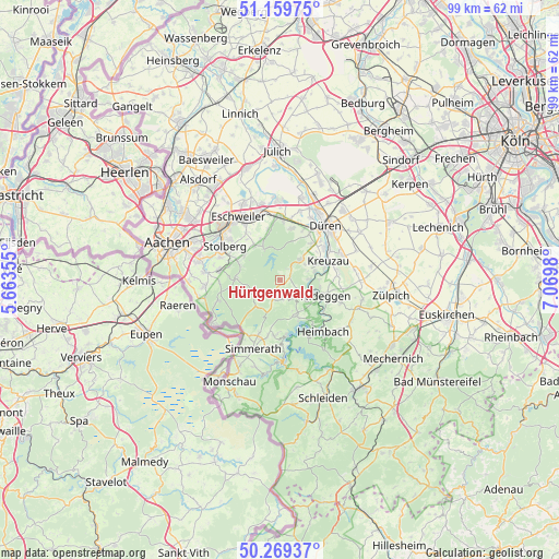
Hürtgenwald GPS coordinates[2]
50° 43' 0.012" North, 6° 22' 0.012" East
| Map corner | latitude | longitude |
|---|---|---|
| Upper-left | 51.15975°, | 5.66355° |
| Center: | 50.71667°, | 6.36667° |
| Lower-right: | 50.26937°, | 7.0698° |
| Map W x H: | 99×99 km | = 61.5×61.5mi |
| max Lat: | 55.01917° ⇑47.5% North |
| Hürtgenwald: | 50.71667° |
| min Lat: | ⇓52.5% South 47.40724° |
| min Long | Hürtgenwald | max Long |
| 5.92978° | 6.36667° | 14.98853° |
| W 1.2%⇐ | ⇒98.8% E |
Elevation
Elevation of Hürtgenwald is 344 m = 1129 ft, and this is 94.9 m = 311 ft above average elevation for this country.
| Max E: |
1256 m = 4121 ft | 31.8% |
| Hürtgenwald | 344 m 1129 ft | |
| Avg. | 249.1 m = 817 ft | |
Min E: |
-5 m = -16 ft | 68.2% |
See also: Germany elevation on elevation.city.
Geographical zone
Hürtgenwald is located in North temperate zone (between Tropic of Cancer and the Arctic Circle). Distance of this North polar circle is 1762 km =1094.9 mi to North.| Distance of | km | miles | from Hürtgenwald |
|---|---|---|---|
| North Pole | 4367.9 | 2714.1 | to North |
| Arctic Circle | 1762 | 1094.9 | to North |
| Tropic Cancer | 3033.2 | 1884.7 | to South |
| Equator | 5639.2 | 3504 | to South |


Nearby cities:
15 places around Hürtgenwald: (largest is in red/bold)
• Breinigerberg
9.3 km =5.8 mi,  284°
284°
• Düren
13.2 km =8.2 mi,  42°
42°
• Einruhr
14.8 km =9.2 mi,  176°
176°
• Eschweiler
13.1 km =8.1 mi,  329°
329°
• Heimbach
11.4 km =7.1 mi,  140°
140°
• Inden
14.1 km =8.8 mi,  358°
358°
• Kreuzau
9.4 km =5.8 mi,  68°
68°
• Langerwehe
11.2 km =7 mi,  353°
353°
• Merzenich
16.5 km =10.3 mi, 42°
• Nideggen
8.7 km =5.4 mi,  107°
107°
• Roetgen
13.9 km =8.6 mi,  237°
237°
• Rurberg
11.5 km =7.1 mi,  174°
174°
• Simmerath
13.8 km =8.6 mi,  199°
199°
• Stolberg
11.8 km =7.3 mi,  302°
302°
• Vettweiß
16.5 km =10.3 mi,  83°
83°
Sources, notices
• [Note1] Compared only with cities in Germany existing in our database
• [Src1] Map data: © OpenStreetMap contributors (CC-BY-SA)
• [Src2] Other city data from geonames.org with taken over terms of usage.
• [Src3] Geographical zone / Annual Mean Temperature by Robert A. Rohde @ Wikipedia
