Stemmen geodata
Stemmen (Lower Saxony) is a seat of a fourth-order administrative division; located in Germany in Europe/Berlin (GMT+2) time zone. With population of 947 people, there are 7359 cities with bigger population in this country. Compared to other cities in Germany, 83% of cities are located further ↓South; 57% of cities are located further →East and 83.2% of cities have higher elevation than Stemmen. Note1


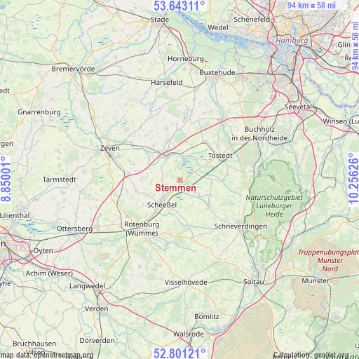
Stemmen GPS coordinates[2]
53° 13' 27.228" North, 9° 33' 11.268" East
| Map corner | latitude | longitude |
|---|---|---|
| Upper-left | 53.64311°, | 8.85001° |
| Center: | 53.22423°, | 9.55313° |
| Lower-right: | 52.80121°, | 10.25626° |
| Map W x H: | 93.6×93.6 km | = 58.2×58.2mi |
| max Lat: | 55.01917° ⇑17% North |
| Stemmen: | 53.22423° |
| min Lat: | ⇓83% South 47.40724° |
| min Long | Stemmen | max Long |
| 5.92978° | 9.55313° | 14.98853° |
| W 43%⇐ | ⇒57% E |
Elevation
Elevation of Stemmen is 39 m = 128 ft, and this is 210.1 m = 689 ft below average elevation for this country.
| Max E: |
1256 m = 4121 ft | 83.2% |
| Avg. | 249.1 m = 817 ft | |
| Stemmen | 39 m = 128 ft | |
Min E: |
-5 m = -16 ft | 16.8% |
See also: Germany elevation on elevation.city.
Geographical zone
Stemmen is located in North temperate zone (between Tropic of Cancer and the Arctic Circle). Distance of this North polar circle is 1483.2 km =921.6 mi to North.| Distance of | km | miles | from Stemmen |
|---|---|---|---|
| North Pole | 4089.1 | 2540.8 | to North |
| Arctic Circle | 1483.2 | 921.6 | to North |
| Tropic Cancer | 3312.1 | 2058 | to South |
| Equator | 5918 | 3677.3 | to South |


Nearby cities:
15 places around Stemmen: (largest is in red/bold)
• Fintel
9.7 km =6 mi,  126°
126°
• Groß Meckelsen
9.5 km =5.9 mi,  313°
313°
• Hamersen
6 km =3.7 mi, 306°
• Helvesiek
4.2 km =2.6 mi,  257°
257°
• Kalbe
7.7 km =4.8 mi,  358°
358°
• Klein Meckelsen
10.9 km =6.8 mi,  320°
320°
• Königsmoor
8.4 km =5.2 mi,  88°
88°
• Lauenbrück
2.8 km =1.7 mi,  161°
161°
• Lengenbostel
8.8 km =5.5 mi,  343°
343°
• Scheeßel
7.9 km =4.9 mi,  215°
215°
• Sittensen
6.6 km =4.1 mi,  330°
330°
• Tiste
6.7 km =4.2 mi,  348°
348°
• Vahlde
6.8 km =4.2 mi, 129°
• Vierden
12.6 km =7.8 mi, 343°
• Wistedt
9.9 km =6.2 mi,  61°
61°
Sources, notices
• [Note1] Compared only with cities in Germany existing in our database
• [Src1] Map data: © OpenStreetMap contributors (CC-BY-SA)
• [Src2] Other city data from geonames.org with taken over terms of usage.
• [Src3] Geographical zone / Annual Mean Temperature by Robert A. Rohde @ Wikipedia
