Fintel geodata
Fintel (Lower Saxony) is a seat of a fourth-order administrative division; located in Germany in Europe/Berlin (GMT+2) time zone. With population of 2,975 people, there are 4023 cities with bigger population in this country. Compared to other cities in Germany, 82.7% of cities are located further ↓South; 54.8% of cities are located further →East and 80.6% of cities have higher elevation than Fintel. Note1


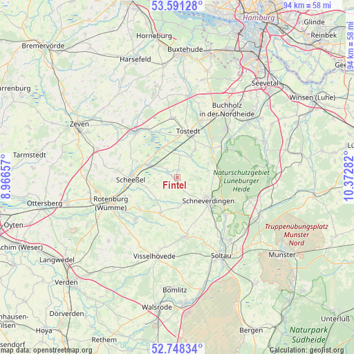
Fintel GPS coordinates[2]
53° 10' 18.768" North, 9° 40' 10.884" East
| Map corner | latitude | longitude |
|---|---|---|
| Upper-left | 53.59128°, | 8.96657° |
| Center: | 53.17188°, | 9.66969° |
| Lower-right: | 52.74834°, | 10.37282° |
| Map W x H: | 93.7×93.7 km | = 58.2×58.2mi |
| max Lat: | 55.01917° ⇑17.3% North |
| Fintel: | 53.17188° |
| min Lat: | ⇓82.7% South 47.40724° |
| min Long | Fintel | max Long |
| 5.92978° | 9.66969° | 14.98853° |
| W 45.2%⇐ | ⇒54.8% E |
Elevation
Elevation of Fintel is 45 m = 148 ft, and this is 204.1 m = 670 ft below average elevation for this country.
| Max E: |
1256 m = 4121 ft | 80.6% |
| Avg. | 249.1 m = 817 ft | |
| Fintel | 45 m = 148 ft | |
Min E: |
-5 m = -16 ft | 19.4% |
See also: Germany elevation on elevation.city.
Geographical zone
Fintel is located in North temperate zone (between Tropic of Cancer and the Arctic Circle). Distance of this North polar circle is 1489 km =925.2 mi to North.| Distance of | km | miles | from Fintel |
|---|---|---|---|
| North Pole | 4094.9 | 2544.5 | to North |
| Arctic Circle | 1489 | 925.2 | to North |
| Tropic Cancer | 3306.2 | 2054.4 | to South |
| Equator | 5912.2 | 3673.7 | to South |


Nearby cities:
15 places around Fintel: (largest is in red/bold)
• Brockel
13 km =8.1 mi,  231°
231°
• Dohren
14.4 km =8.9 mi,  8°
8°
• Handeloh
14 km =8.7 mi,  54°
54°
• Helvesiek
12.8 km =8 mi,  292°
292°
• Hemslingen
10.9 km =6.8 mi,  205°
205°
• Königsmoor
6.1 km =3.8 mi, 6°
• Lauenbrück
7.5 km =4.7 mi, 294°
• Otter
9 km =5.6 mi,  32°
32°
• Scheeßel
12.4 km =7.7 mi,  267°
267°
• Schneverdingen
10.4 km =6.5 mi,  126°
126°
• Stemmen
9.7 km =6 mi,  306°
306°
• Tostedt
12.8 km =8 mi, 14°
• Vahlde
2.9 km =1.8 mi,  300°
300°
• Welle
11.6 km =7.2 mi, 49°
• Wistedt
10.6 km =6.6 mi,  4°
4°
Sources, notices
• [Note1] Compared only with cities in Germany existing in our database
• [Src1] Map data: © OpenStreetMap contributors (CC-BY-SA)
• [Src2] Other city data from geonames.org with taken over terms of usage.
• [Src3] Geographical zone / Annual Mean Temperature by Robert A. Rohde @ Wikipedia
