Stelzenberg geodata
Stelzenberg (Rheinland-Pfalz) is a seat of a fourth-order administrative division; located in Germany in Europe/Berlin (GMT+2) time zone. With population of 1,291 people, there are 6334 cities with bigger population in this country. Compared to other cities in Germany, 77.5% of cities are located further ↑North; 82.3% of cities are located further →East and 72.6% of cities have lower elevation than Stelzenberg. Note1
Administrative division(s):
- Level 1: Rheinland-Pfalz
- Level 3: Landkreis Kaiserslautern
- Level 4: Stelzenberg


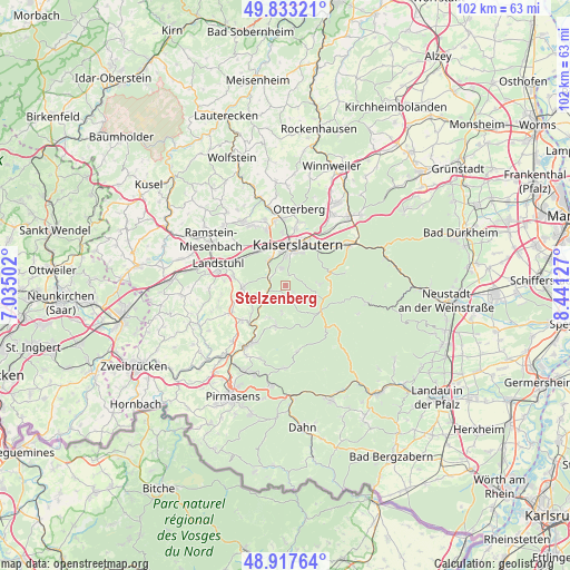
Stelzenberg GPS coordinates[2]
49° 22' 39.216" North, 7° 44' 17.304" East
| Map corner | latitude | longitude |
|---|---|---|
| Upper-left | 49.83321°, | 7.03502° |
| Center: | 49.37756°, | 7.73814° |
| Lower-right: | 48.91764°, | 8.44127° |
| Map W x H: | 101.8×101.8 km | = 63.3×63.3mi |
| max Lat: | 55.01917° ⇑77.5% North |
| Stelzenberg: | 49.37756° |
| min Lat: | ⇓22.5% South 47.40724° |
| min Long | Stelzenberg | max Long |
| 5.92978° | 7.73814° | 14.98853° |
| W 17.7%⇐ | ⇒82.3% E |
Elevation
Elevation of Stelzenberg is 379 m = 1243 ft, and this is 129.9 m = 426 ft above average elevation for this country.
| Max E: |
1256 m = 4121 ft | 27.4% |
| Stelzenberg | 379 m 1243 ft | |
| Avg. | 249.1 m = 817 ft | |
Min E: |
-5 m = -16 ft | 72.6% |
See also: Germany elevation on elevation.city.
Geographical zone
Stelzenberg is located in North temperate zone (between Tropic of Cancer and the Arctic Circle). Distance of this North polar circle is 1910.9 km =1187.4 mi to North.| Distance of | km | miles | from Stelzenberg |
|---|---|---|---|
| North Pole | 4516.8 | 2806.6 | to North |
| Arctic Circle | 1910.9 | 1187.4 | to North |
| Tropic Cancer | 2884.4 | 1792.3 | to South |
| Equator | 5490.3 | 3411.5 | to South |


Nearby cities:
15 places around Stelzenberg: (largest is in red/bold)
• Bann
8.8 km =5.5 mi,  274°
274°
• Geiselberg
6.5 km =4 mi,  207°
207°
• Heltersberg
6.9 km =4.3 mi,  192°
192°
• Hermersberg
10.2 km =6.3 mi,  228°
228°
• Horbach
8.1 km =5 mi, 232°
• Kaiserslautern
7.7 km =4.8 mi,  18°
18°
• Kindsbach
9.8 km =6.1 mi,  296°
296°
• Krickenbach
5.3 km =3.3 mi,  256°
256°
• Linden
7.1 km =4.4 mi,  244°
244°
• Queidersbach
7.7 km =4.8 mi, 260°
• Schmalenberg
4.9 km =3 mi,  184°
184°
• Schopp
5 km =3.1 mi, 232°
• Steinalben
9.3 km =5.8 mi,  223°
223°
• Trippstadt
3.3 km =2.1 mi,  127°
127°
• Weselberg
10.5 km =6.5 mi, 244°
Sources, notices
• [Note1] Compared only with cities in Germany existing in our database
• [Src1] Map data: © OpenStreetMap contributors (CC-BY-SA)
• [Src2] Other city data from geonames.org with taken over terms of usage.
• [Src3] Geographical zone / Annual Mean Temperature by Robert A. Rohde @ Wikipedia
