Schmalenberg geodata
Schmalenberg (Rheinland-Pfalz) is a seat of a fourth-order administrative division; located in Germany in Europe/Berlin (GMT+2) time zone. With population of 814 people, there are 7845 cities with bigger population in this country. Compared to other cities in Germany, 78.2% of cities are located further ↑North; 82.5% of cities are located further →East and 82.4% of cities have lower elevation than Schmalenberg. Note1


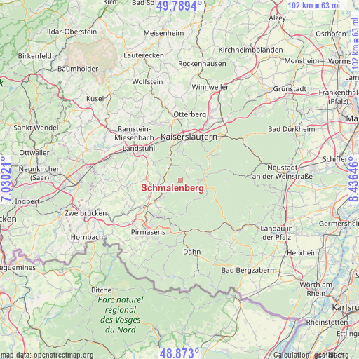
Schmalenberg GPS coordinates[2]
49° 19' 59.988" North, 7° 43' 59.988" East
| Map corner | latitude | longitude |
|---|---|---|
| Upper-left | 49.7894°, | 7.03021° |
| Center: | 49.33333°, | 7.73333° |
| Lower-right: | 48.873°, | 8.43646° |
| Map W x H: | 101.9×101.9 km | = 63.3×63.3mi |
| max Lat: | 55.01917° ⇑78.2% North |
| Schmalenberg: | 49.33333° |
| min Lat: | ⇓21.8% South 47.40724° |
| min Long | Schmalenberg | max Long |
| 5.92978° | 7.73333° | 14.98853° |
| W 17.5%⇐ | ⇒82.5% E |
Elevation
Elevation of Schmalenberg is 449 m = 1473 ft, and this is 199.9 m = 656 ft above average elevation for this country.
| Max E: |
1256 m = 4121 ft | 17.6% |
| Schmalenberg | 449 m 1473 ft | |
| Avg. | 249.1 m = 817 ft | |
Min E: |
-5 m = -16 ft | 82.4% |
See also: Germany elevation on elevation.city.
Geographical zone
Schmalenberg is located in North temperate zone (between Tropic of Cancer and the Arctic Circle). Distance of this North polar circle is 1915.8 km =1190.4 mi to North.| Distance of | km | miles | from Schmalenberg |
|---|---|---|---|
| North Pole | 4521.7 | 2809.7 | to North |
| Arctic Circle | 1915.8 | 1190.4 | to North |
| Tropic Cancer | 2879.4 | 1789.2 | to South |
| Equator | 5485.4 | 3408.5 | to South |


Nearby cities:
15 places around Schmalenberg: (largest is in red/bold)
• Clausen
9 km =5.6 mi,  206°
206°
• Geiselberg
2.7 km =1.7 mi,  252°
252°
• Heltersberg
2.2 km =1.4 mi, 213°
• Hermersberg
7.5 km =4.7 mi,  255°
255°
• Horbach
6 km =3.7 mi,  270°
270°
• Krickenbach
6.1 km =3.8 mi,  307°
307°
• Leimen
7.1 km =4.4 mi,  158°
158°
• Linden
6.3 km =3.9 mi,  287°
287°
• Queidersbach
8.1 km =5 mi,  297°
297°
• Schopp
4.1 km =2.5 mi, 297°
• Steinalben
6.3 km =3.9 mi, 252°
• Stelzenberg
4.9 km =3 mi,  4°
4°
• Trippstadt
4.2 km =2.6 mi,  46°
46°
• Waldfischbach-Burgalben
7.4 km =4.6 mi,  220°
220°
• Weselberg
9.1 km =5.7 mi, 272°
Sources, notices
• [Note1] Compared only with cities in Germany existing in our database
• [Src1] Map data: © OpenStreetMap contributors (CC-BY-SA)
• [Src2] Other city data from geonames.org with taken over terms of usage.
• [Src3] Geographical zone / Annual Mean Temperature by Robert A. Rohde @ Wikipedia
