Steinheim geodata
Steinheim (Bavaria) is a populated place; located in Germany in Europe/Berlin (GMT+2) time zone. With population of 2,878 people, there are 4118 cities with bigger population in this country. Compared to other cities in Germany, 95.4% of cities are located further ↑North; 52.7% of cities are located further ←West and 94.4% of cities have lower elevation than Steinheim. Note1
Administrative division(s):
- Level 1: Bavaria
- Level 2: Swabia
- Level 3: Kreisfreie Stadt Memmingen
- Level 4: Memmingen


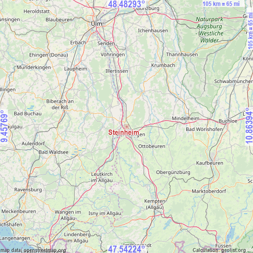
Steinheim GPS coordinates[2]
48° 0' 53.028" North, 10° 9' 38.916" East
| Map corner | latitude | longitude |
|---|---|---|
| Upper-left | 48.48293°, | 9.45769° |
| Center: | 48.01473°, | 10.16081° |
| Lower-right: | 47.54224°, | 10.86394° |
| Map W x H: | 104.6×104.6 km | = 65×65mi |
| max Lat: | 55.01917° ⇑95.4% North |
| Steinheim: | 48.01473° |
| min Lat: | ⇓4.6% South 47.40724° |
| min Long | Steinheim | max Long |
| 5.92978° | 10.16081° | 14.98853° |
| W 52.7%⇐ | ⇒47.3% E |
Elevation
Elevation of Steinheim is 586 m = 1923 ft, and this is 336.9 m = 1105 ft above average elevation for this country.
| Max E: |
1256 m = 4121 ft | 5.6% |
| Steinheim | 586 m 1923 ft | |
| Avg. | 249.1 m = 817 ft | |
Min E: |
-5 m = -16 ft | 94.4% |
See also: Germany elevation on elevation.city.
Geographical zone
Steinheim is located in North temperate zone (between Tropic of Cancer and the Arctic Circle). Distance of this North polar circle is 2062.4 km =1281.5 mi to North.| Distance of | km | miles | from Steinheim |
|---|---|---|---|
| North Pole | 4668.3 | 2900.7 | to North |
| Arctic Circle | 2062.4 | 1281.5 | to North |
| Tropic Cancer | 2732.8 | 1698.1 | to South |
| Equator | 5338.7 | 3317.3 | to South |


Nearby cities:
15 places around Steinheim: (largest is in red/bold)
• Amendingen
1.9 km =1.2 mi,  133°
133°
• Benningen
6.8 km =4.2 mi,  142°
142°
• Berkheim
6.6 km =4.1 mi,  297°
297°
• Boos
7.2 km =4.5 mi,  20°
20°
• Buxheim
2.6 km =1.6 mi,  231°
231°
• Dickenreishausen
6.9 km =4.3 mi,  174°
174°
• Eisenburg
3.6 km =2.2 mi,  91°
91°
• Fellheim
6.5 km =4 mi,  354°
354°
• Heimertingen
2.2 km =1.4 mi,  338°
338°
• Kirchdorf
7.3 km =4.5 mi, 339°
• Memmingen
3.9 km =2.4 mi,  152°
152°
• Memmingerberg
5.5 km =3.4 mi,  122°
122°
• Niederrieden
5 km =3.1 mi, 19°
• Tannheim
6 km =3.7 mi,  254°
254°
• Trunkelsberg
4.5 km =2.8 mi,  111°
111°
Sources, notices
• [Note1] Compared only with cities in Germany existing in our database
• [Src1] Map data: © OpenStreetMap contributors (CC-BY-SA)
• [Src2] Other city data from geonames.org with taken over terms of usage.
• [Src3] Geographical zone / Annual Mean Temperature by Robert A. Rohde @ Wikipedia
