Steffeln geodata
Steffeln (Rheinland-Pfalz) is a seat of a fourth-order administrative division; located in Germany in Europe/Berlin (GMT+2) time zone. With population of 685 people, there are 8387 cities with bigger population in this country. Compared to other cities in Germany, 57.2% of cities are located further ↑North; 97.4% of cities are located further →East and 88.1% of cities have lower elevation than Steffeln. Note1


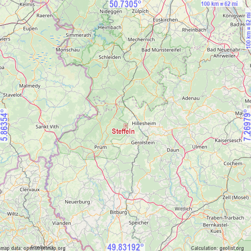
Steffeln GPS coordinates[2]
50° 16' 59.988" North, 6° 34' 0.012" East
| Map corner | latitude | longitude |
|---|---|---|
| Upper-left | 50.7305°, | 5.86354° |
| Center: | 50.28333°, | 6.56667° |
| Lower-right: | 49.83192°, | 7.26979° |
| Map W x H: | 99.9×99.9 km | = 62.1×62.1mi |
| max Lat: | 55.01917° ⇑57.2% North |
| Steffeln: | 50.28333° |
| min Lat: | ⇓42.8% South 47.40724° |
| min Long | Steffeln | max Long |
| 5.92978° | 6.56667° | 14.98853° |
| W 2.6%⇐ | ⇒97.4% E |
Elevation
Elevation of Steffeln is 495 m = 1624 ft, and this is 245.9 m = 807 ft above average elevation for this country.
| Max E: |
1256 m = 4121 ft | 11.9% |
| Steffeln | 495 m 1624 ft | |
| Avg. | 249.1 m = 817 ft | |
Min E: |
-5 m = -16 ft | 88.1% |
See also: Germany elevation on elevation.city.
Geographical zone
Steffeln is located in North temperate zone (between Tropic of Cancer and the Arctic Circle). Distance of this North polar circle is 1810.2 km =1124.8 mi to North.| Distance of | km | miles | from Steffeln |
|---|---|---|---|
| North Pole | 4416.1 | 2744 | to North |
| Arctic Circle | 1810.2 | 1124.8 | to North |
| Tropic Cancer | 2985.1 | 1854.9 | to South |
| Equator | 5591 | 3474.1 | to South |


Nearby cities:
15 places around Steffeln: (largest is in red/bold)
• Basberg
3 km =1.9 mi,  51°
51°
• Birgel
5.1 km =3.2 mi,  43°
43°
• Dohm-Lammersdorf
7.3 km =4.5 mi,  104°
104°
• Duppach
1.9 km =1.2 mi,  180°
180°
• Gönnersdorf
6 km =3.7 mi,  23°
23°
• Hillesheim
7.4 km =4.6 mi,  82°
82°
• Jünkerath
6.8 km =4.2 mi,  8°
8°
• Kalenborn-Scheuern
4.4 km =2.7 mi,  147°
147°
• Kleinlangenfeld
6.2 km =3.9 mi,  252°
252°
• Lissendorf
4.4 km =2.7 mi,  32°
32°
• Neuendorf
7.1 km =4.4 mi,  270°
270°
• Oberbettingen
4.7 km =2.9 mi,  90°
90°
• Reuth
6.2 km =3.9 mi,  287°
287°
• Schwirzheim
6 km =3.7 mi,  203°
203°
• Schüller
5.7 km =3.5 mi, 12°
Sources, notices
• [Note1] Compared only with cities in Germany existing in our database
• [Src1] Map data: © OpenStreetMap contributors (CC-BY-SA)
• [Src2] Other city data from geonames.org with taken over terms of usage.
• [Src3] Geographical zone / Annual Mean Temperature by Robert A. Rohde @ Wikipedia
