Seibersbach geodata
Seibersbach (Rheinland-Pfalz) is a seat of a fourth-order administrative division; located in Germany in Europe/Berlin (GMT+2) time zone. With population of 1,457 people, there are 5966 cities with bigger population in this country. Compared to other cities in Germany, 64.8% of cities are located further ↑North; 82.8% of cities are located further →East and 80.1% of cities have lower elevation than Seibersbach. Note1
Administrative division(s):
- Level 1: Rheinland-Pfalz
- Level 3: Landkreis Bad Kreuznach
- Level 4: Seibersbach


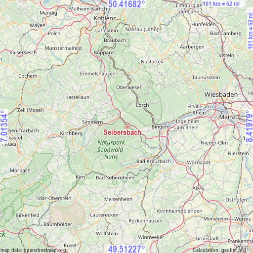
Seibersbach GPS coordinates[2]
49° 58' 0.012" North, 7° 43' 0.012" East
| Map corner | latitude | longitude |
|---|---|---|
| Upper-left | 50.41682°, | 7.01354° |
| Center: | 49.96667°, | 7.71667° |
| Lower-right: | 49.51227°, | 8.41979° |
| Map W x H: | 100.6×100.6 km | = 62.5×62.5mi |
| max Lat: | 55.01917° ⇑64.8% North |
| Seibersbach: | 49.96667° |
| min Lat: | ⇓35.2% South 47.40724° |
| min Long | Seibersbach | max Long |
| 5.92978° | 7.71667° | 14.98853° |
| W 17.2%⇐ | ⇒82.8% E |
Elevation
Elevation of Seibersbach is 433 m = 1421 ft, and this is 183.9 m = 603 ft above average elevation for this country.
| Max E: |
1256 m = 4121 ft | 19.9% |
| Seibersbach | 433 m 1421 ft | |
| Avg. | 249.1 m = 817 ft | |
Min E: |
-5 m = -16 ft | 80.1% |
See also: Germany elevation on elevation.city.
Geographical zone
Seibersbach is located in North temperate zone (between Tropic of Cancer and the Arctic Circle). Distance of this North polar circle is 1845.4 km =1146.7 mi to North.| Distance of | km | miles | from Seibersbach |
|---|---|---|---|
| North Pole | 4451.3 | 2765.9 | to North |
| Arctic Circle | 1845.4 | 1146.7 | to North |
| Tropic Cancer | 2949.9 | 1833 | to South |
| Equator | 5555.8 | 3452.2 | to South |


Nearby cities:
15 places around Seibersbach: (largest is in red/bold)
• Dalberg
7.5 km =4.7 mi,  170°
170°
• Daxweiler
2.4 km =1.5 mi,  90°
90°
• Dichtelbach
4.9 km =3 mi,  342°
342°
• Dörrebach
2.4 km =1.5 mi, 173°
• Eckenroth
7.3 km =4.5 mi,  139°
139°
• Ellern
5.5 km =3.4 mi,  287°
287°
• Oberheimbach
7.3 km =4.5 mi,  40°
40°
• Rheinböllen
5.9 km =3.7 mi,  327°
327°
• Roth
7 km =4.3 mi,  121°
121°
• Schnorbach
7.4 km =4.6 mi,  284°
284°
• Schweppenhausen
7.4 km =4.6 mi,  126°
126°
• Schöneberg
6 km =3.7 mi,  156°
156°
• Spabrücken
7.4 km =4.6 mi,  180°
180°
• Stromberg
4.8 km =3 mi, 122°
• Warmsroth
5.1 km =3.2 mi,  111°
111°
Sources, notices
• [Note1] Compared only with cities in Germany existing in our database
• [Src1] Map data: © OpenStreetMap contributors (CC-BY-SA)
• [Src2] Other city data from geonames.org with taken over terms of usage.
• [Src3] Geographical zone / Annual Mean Temperature by Robert A. Rohde @ Wikipedia
