Oberheimbach geodata
Oberheimbach (Rheinland-Pfalz) is a seat of a fourth-order administrative division; located in Germany in Europe/Berlin (GMT+2) time zone. With population of 705 people, there are 8290 cities with bigger population in this country. Compared to other cities in Germany, 63.5% of cities are located further ↑North; 81.3% of cities are located further →East and 54.2% of cities have lower elevation than Oberheimbach. Note1
Administrative division(s):
- Level 1: Rheinland-Pfalz
- Level 3: Landkreis Mainz-Bingen
- Level 4: Oberheimbach


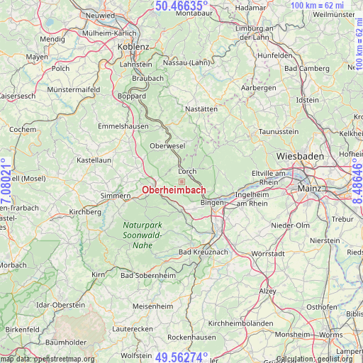
Oberheimbach GPS coordinates[2]
50° 1' 0.012" North, 7° 46' 59.988" East
| Map corner | latitude | longitude |
|---|---|---|
| Upper-left | 50.46635°, | 7.08021° |
| Center: | 50.01667°, | 7.78333° |
| Lower-right: | 49.56274°, | 8.48646° |
| Map W x H: | 100.5×100.5 km | = 62.4×62.4mi |
| max Lat: | 55.01917° ⇑63.5% North |
| Oberheimbach: | 50.01667° |
| min Lat: | ⇓36.5% South 47.40724° |
| min Long | Oberheimbach | max Long |
| 5.92978° | 7.78333° | 14.98853° |
| W 18.7%⇐ | ⇒81.3% E |
Elevation
Elevation of Oberheimbach is 253 m = 830 ft, and this is 3.9 m = 13 ft above average elevation for this country.
| Max E: |
1256 m = 4121 ft | 45.8% |
| Oberheimbach | 253 m 830 ft | |
| Avg. | 249.1 m = 817 ft | |
Min E: |
-5 m = -16 ft | 54.2% |
See also: Germany elevation on elevation.city.
Geographical zone
Oberheimbach is located in North temperate zone (between Tropic of Cancer and the Arctic Circle). Distance of this North polar circle is 1839.8 km =1143.2 mi to North.| Distance of | km | miles | from Oberheimbach |
|---|---|---|---|
| North Pole | 4445.7 | 2762.4 | to North |
| Arctic Circle | 1839.8 | 1143.2 | to North |
| Tropic Cancer | 2955.4 | 1836.4 | to South |
| Equator | 5561.3 | 3455.6 | to South |


Nearby cities:
15 places around Oberheimbach: (largest is in red/bold)
• Bacharach
4.6 km =2.9 mi,  347°
347°
• Breitscheid
7 km =4.3 mi,  301°
301°
• Daxweiler
6 km =3.7 mi,  203°
203°
• Dichtelbach
6.3 km =3.9 mi,  261°
261°
• Erbach
7.4 km =4.6 mi,  284°
284°
• Manubach
3 km =1.9 mi,  307°
307°
• Niederheimbach
3 km =1.9 mi,  52°
52°
• Oberdiebach
1.9 km =1.2 mi,  0°
0°
• Perscheid
8.1 km =5 mi, 313°
• Rheinböllen
7.9 km =4.9 mi,  265°
265°
• Sauerthal
8.1 km =5 mi,  19°
19°
• Seibersbach
7.3 km =4.5 mi,  220°
220°
• Stromberg
8.1 km =5 mi,  185°
185°
• Trechtingshausen
4.6 km =2.9 mi,  98°
98°
• Warmsroth
7.4 km =4.6 mi,  180°
180°
Sources, notices
• [Note1] Compared only with cities in Germany existing in our database
• [Src1] Map data: © OpenStreetMap contributors (CC-BY-SA)
• [Src2] Other city data from geonames.org with taken over terms of usage.
• [Src3] Geographical zone / Annual Mean Temperature by Robert A. Rohde @ Wikipedia
