Seeth-Ekholt geodata
Seeth-Ekholt (Schleswig-Holstein) is a seat of a fourth-order administrative division; located in Germany in Europe/Berlin (GMT+2) time zone. With population of 853 people, there are 7690 cities with bigger population in this country. Compared to other cities in Germany, 89.2% of cities are located further ↓South; 53.9% of cities are located further →East and 92.7% of cities have higher elevation than Seeth-Ekholt. Note1
Administrative division(s):
- Level 1: Schleswig-Holstein
- Level 3: Kreis Pinneberg
- Level 4: Seeth-Ekholt


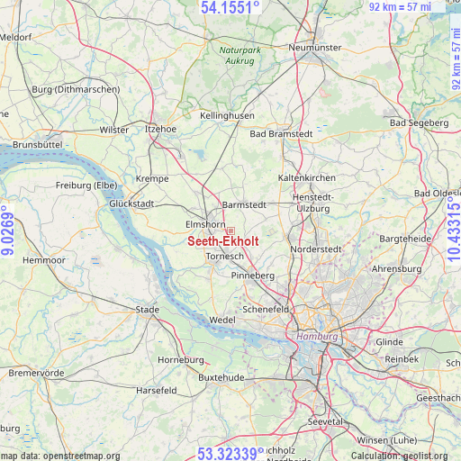
Seeth-Ekholt GPS coordinates[2]
53° 44' 28.68" North, 9° 43' 48.072" East
| Map corner | latitude | longitude |
|---|---|---|
| Upper-left | 54.1551°, | 9.0269° |
| Center: | 53.7413°, | 9.73002° |
| Lower-right: | 53.32339°, | 10.43315° |
| Map W x H: | 92.5×92.5 km | = 57.5×57.5mi |
| max Lat: | 55.01917° ⇑10.8% North |
| Seeth-Ekholt: | 53.7413° |
| min Lat: | ⇓89.2% South 47.40724° |
| min Long | Seeth-Ekholt | max Long |
| 5.92978° | 9.73002° | 14.98853° |
| W 46.1%⇐ | ⇒53.9% E |
Elevation
Elevation of Seeth-Ekholt is 14 m = 46 ft, and this is 235.1 m = 771 ft below average elevation for this country.
| Max E: |
1256 m = 4121 ft | 92.7% |
| Avg. | 249.1 m = 817 ft | |
| Seeth-Ekholt | 14 m = 46 ft | |
Min E: |
-5 m = -16 ft | 7.3% |
See also: Germany elevation on elevation.city.
Geographical zone
Seeth-Ekholt is located in North temperate zone (between Tropic of Cancer and the Arctic Circle). Distance of this North polar circle is 1425.7 km =885.9 mi to North.| Distance of | km | miles | from Seeth-Ekholt |
|---|---|---|---|
| North Pole | 4031.6 | 2505.1 | to North |
| Arctic Circle | 1425.7 | 885.9 | to North |
| Tropic Cancer | 3369.6 | 2093.8 | to South |
| Equator | 5975.5 | 3713 | to South |


Nearby cities:
15 places around Seeth-Ekholt: (largest is in red/bold)
• Barmstedt
6.2 km =3.9 mi,  23°
23°
• Bevern
3.1 km =1.9 mi,  58°
58°
• Bokholt-Hanredder
5.2 km =3.2 mi,  4°
4°
• Bullenkuhlen
3.1 km =1.9 mi, 24°
• Ellerhoop
3.1 km =1.9 mi,  123°
123°
• Elmshorn
5.2 km =3.2 mi,  285°
285°
• Heede
6.6 km =4.1 mi,  44°
44°
• Heidgraben
4.9 km =3 mi,  220°
220°
• Klein Nordende
5.4 km =3.4 mi,  246°
246°
• Klein Offenseth-Sparrieshoop
6.9 km =4.3 mi,  335°
335°
• Kummerfeld
6.7 km =4.2 mi,  143°
143°
• Kölln-Reisiek
2.8 km =1.7 mi,  310°
310°
• Prisdorf
6.6 km =4.1 mi,  168°
168°
• Seeth
1 km =0.6 mi,  175°
175°
• Tornesch
4.7 km =2.9 mi,  190°
190°
Sources, notices
• [Note1] Compared only with cities in Germany existing in our database
• [Src1] Map data: © OpenStreetMap contributors (CC-BY-SA)
• [Src2] Other city data from geonames.org with taken over terms of usage.
• [Src3] Geographical zone / Annual Mean Temperature by Robert A. Rohde @ Wikipedia
