Ellerhoop geodata
Ellerhoop (Schleswig-Holstein) is a seat of a fourth-order administrative division; located in Germany in Europe/Berlin (GMT+2) time zone. With population of 1,304 people, there are 6297 cities with bigger population in this country. Compared to other cities in Germany, 89% of cities are located further ↓South; 53.2% of cities are located further →East and 93.5% of cities have higher elevation than Ellerhoop. Note1


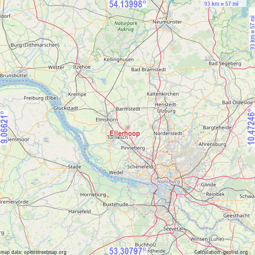
Ellerhoop GPS coordinates[2]
53° 43' 33.708" North, 9° 46' 9.588" East
| Map corner | latitude | longitude |
|---|---|---|
| Upper-left | 54.13998°, | 9.06621° |
| Center: | 53.72603°, | 9.76933° |
| Lower-right: | 53.30797°, | 10.47246° |
| Map W x H: | 92.5×92.5 km | = 57.5×57.5mi |
| max Lat: | 55.01917° ⇑11% North |
| Ellerhoop: | 53.72603° |
| min Lat: | ⇓89% South 47.40724° |
| min Long | Ellerhoop | max Long |
| 5.92978° | 9.76933° | 14.98853° |
| W 46.8%⇐ | ⇒53.2% E |
Elevation
Elevation of Ellerhoop is 12 m = 39 ft, and this is 237.1 m = 778 ft below average elevation for this country.
| Max E: |
1256 m = 4121 ft | 93.5% |
| Avg. | 249.1 m = 817 ft | |
| Ellerhoop | 12 m = 39 ft | |
Min E: |
-5 m = -16 ft | 6.5% |
See also: Germany elevation on elevation.city.
Geographical zone
Ellerhoop is located in North temperate zone (between Tropic of Cancer and the Arctic Circle). Distance of this North polar circle is 1427.4 km =886.9 mi to North.| Distance of | km | miles | from Ellerhoop |
|---|---|---|---|
| North Pole | 4033.3 | 2506.2 | to North |
| Arctic Circle | 1427.4 | 886.9 | to North |
| Tropic Cancer | 3367.9 | 2092.7 | to South |
| Equator | 5973.8 | 3711.9 | to South |


Nearby cities:
15 places around Ellerhoop: (largest is in red/bold)
• Barmstedt
7.3 km =4.5 mi,  359°
359°
• Bevern
3.3 km =2.1 mi,  1°
1°
• Bokholt-Hanredder
7.2 km =4.5 mi,  342°
342°
• Borstel-Hohenraden
5.7 km =3.5 mi,  146°
146°
• Bullenkuhlen
4.7 km =2.9 mi, 344°
• Heede
6.7 km =4.2 mi,  17°
17°
• Heidgraben
6.2 km =3.9 mi,  250°
250°
• Hemdingen
6.2 km =3.9 mi,  42°
42°
• Kummerfeld
4 km =2.5 mi,  159°
159°
• Kölln-Reisiek
5.9 km =3.7 mi,  306°
306°
• Pinneberg
6.7 km =4.2 mi,  168°
168°
• Prisdorf
4.9 km =3 mi,  195°
195°
• Seeth
2.6 km =1.6 mi,  284°
284°
• Seeth-Ekholt
3.1 km =1.9 mi,  303°
303°
• Tornesch
4.5 km =2.8 mi,  230°
230°
Sources, notices
• [Note1] Compared only with cities in Germany existing in our database
• [Src1] Map data: © OpenStreetMap contributors (CC-BY-SA)
• [Src2] Other city data from geonames.org with taken over terms of usage.
• [Src3] Geographical zone / Annual Mean Temperature by Robert A. Rohde @ Wikipedia
