Schlierschied geodata
Schlierschied (Rheinland-Pfalz) is a seat of a fourth-order administrative division; located in Germany in Europe/Berlin (GMT+2) time zone. With population of 190 people, there are 10516 cities with bigger population in this country. Compared to other cities in Germany, 67.4% of cities are located further ↑North; 88.2% of cities are located further →East and 80.9% of cities have lower elevation than Schlierschied. Note1
Administrative division(s):
- Level 1: Rheinland-Pfalz
- Level 3: Rhein-Hunsrück-Kreis
- Level 4: Schlierschied


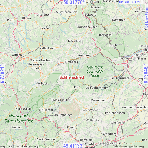
Schlierschied GPS coordinates[2]
49° 52' 0.012" North, 7° 25' 59.988" East
| Map corner | latitude | longitude |
|---|---|---|
| Upper-left | 50.31776°, | 6.73021° |
| Center: | 49.86667°, | 7.43333° |
| Lower-right: | 49.41133°, | 8.13646° |
| Map W x H: | 100.8×100.8 km | = 62.6×62.6mi |
| max Lat: | 55.01917° ⇑67.4% North |
| Schlierschied: | 49.86667° |
| min Lat: | ⇓32.6% South 47.40724° |
| min Long | Schlierschied | max Long |
| 5.92978° | 7.43333° | 14.98853° |
| W 11.8%⇐ | ⇒88.2% E |
Elevation
Elevation of Schlierschied is 439 m = 1440 ft, and this is 189.9 m = 623 ft above average elevation for this country.
| Max E: |
1256 m = 4121 ft | 19.1% |
| Schlierschied | 439 m 1440 ft | |
| Avg. | 249.1 m = 817 ft | |
Min E: |
-5 m = -16 ft | 80.9% |
See also: Germany elevation on elevation.city.
Geographical zone
Schlierschied is located in North temperate zone (between Tropic of Cancer and the Arctic Circle). Distance of this North polar circle is 1856.5 km =1153.6 mi to North.| Distance of | km | miles | from Schlierschied |
|---|---|---|---|
| North Pole | 4462.4 | 2772.8 | to North |
| Arctic Circle | 1856.5 | 1153.6 | to North |
| Tropic Cancer | 2938.7 | 1826 | to South |
| Equator | 5544.7 | 3445.3 | to South |


Nearby cities:
15 places around Schlierschied: (largest is in red/bold)
• Bruschied
4.4 km =2.7 mi,  212°
212°
• Bundenbach
4.8 km =3 mi,  236°
236°
• Dickenschied
3.9 km =2.4 mi,  342°
342°
• Gehlweiler
3 km =1.9 mi,  52°
52°
• Gemünden
4.4 km =2.7 mi, 45°
• Hausen
4.8 km =3 mi,  270°
270°
• Henau
4.8 km =3 mi,  90°
90°
• Hennweiler
5.6 km =3.5 mi,  180°
180°
• Kellenbach
4 km =2.5 mi,  117°
117°
• Königsau
4 km =2.5 mi, 117°
• Lindenschied
4.4 km =2.7 mi,  327°
327°
• Oberkirn
5.1 km =3.2 mi,  291°
291°
• Rohrbach
2.2 km =1.4 mi, 327°
• Womrath
5.7 km =3.5 mi,  12°
12°
• Woppenroth
1.2 km =0.7 mi, 270°
Sources, notices
• [Note1] Compared only with cities in Germany existing in our database
• [Src1] Map data: © OpenStreetMap contributors (CC-BY-SA)
• [Src2] Other city data from geonames.org with taken over terms of usage.
• [Src3] Geographical zone / Annual Mean Temperature by Robert A. Rohde @ Wikipedia
