Gehlweiler geodata
Gehlweiler (Rheinland-Pfalz) is a seat of a fourth-order administrative division; located in Germany in Europe/Berlin (GMT+2) time zone. With population of 254 people, there are 10244 cities with bigger population in this country. Compared to other cities in Germany, 67% of cities are located further ↑North; 87.7% of cities are located further →East and 60.9% of cities have lower elevation than Gehlweiler. Note1
Administrative division(s):
- Level 1: Rheinland-Pfalz
- Level 3: Rhein-Hunsrück-Kreis
- Level 4: Gehlweiler


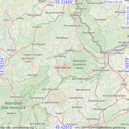
Gehlweiler GPS coordinates[2]
49° 52' 59.988" North, 7° 28' 0.012" East
| Map corner | latitude | longitude |
|---|---|---|
| Upper-left | 50.33426°, | 6.76354° |
| Center: | 49.88333°, | 7.46667° |
| Lower-right: | 49.42815°, | 8.16979° |
| Map W x H: | 100.7×100.7 km | = 62.6×62.6mi |
| max Lat: | 55.01917° ⇑67% North |
| Gehlweiler: | 49.88333° |
| min Lat: | ⇓33% South 47.40724° |
| min Long | Gehlweiler | max Long |
| 5.92978° | 7.46667° | 14.98853° |
| W 12.3%⇐ | ⇒87.7% E |
Elevation
Elevation of Gehlweiler is 295 m = 968 ft, and this is 45.9 m = 151 ft above average elevation for this country.
| Max E: |
1256 m = 4121 ft | 39.1% |
| Gehlweiler | 295 m 968 ft | |
| Avg. | 249.1 m = 817 ft | |
Min E: |
-5 m = -16 ft | 60.9% |
See also: Germany elevation on elevation.city.
Geographical zone
Gehlweiler is located in North temperate zone (between Tropic of Cancer and the Arctic Circle). Distance of this North polar circle is 1854.7 km =1152.5 mi to North.| Distance of | km | miles | from Gehlweiler |
|---|---|---|---|
| North Pole | 4460.6 | 2771.7 | to North |
| Arctic Circle | 1854.7 | 1152.5 | to North |
| Tropic Cancer | 2940.6 | 1827.2 | to South |
| Equator | 5546.5 | 3446.4 | to South |


Nearby cities:
15 places around Gehlweiler: (largest is in red/bold)
• Dickenschied
4 km =2.5 mi,  297°
297°
• Gemünden
1.5 km =0.9 mi,  32°
32°
• Hecken
6 km =3.7 mi,  307°
307°
• Henau
3 km =1.9 mi,  127°
127°
• Kellenbach
3.9 km =2.4 mi,  162°
162°
• Königsau
3.9 km =2.4 mi, 162°
• Lindenschied
5.1 km =3.2 mi,  291°
291°
• Mengerschied
4.4 km =2.7 mi, 32°
• Ravengiersburg
5.7 km =3.5 mi,  12°
12°
• Rohrbach
3.6 km =2.2 mi,  270°
270°
• Schlierschied
3 km =1.9 mi,  232°
232°
• Schwarzerden
5.2 km =3.2 mi,  135°
135°
• Weitersborn
6 km =3.7 mi, 127°
• Womrath
3.9 km =2.4 mi,  342°
342°
• Woppenroth
4 km =2.5 mi,  242°
242°
Sources, notices
• [Note1] Compared only with cities in Germany existing in our database
• [Src1] Map data: © OpenStreetMap contributors (CC-BY-SA)
• [Src2] Other city data from geonames.org with taken over terms of usage.
• [Src3] Geographical zone / Annual Mean Temperature by Robert A. Rohde @ Wikipedia
