Rumohr geodata
Rumohr (Schleswig-Holstein) is a seat of a fourth-order administrative division; located in Germany in Europe/Berlin (GMT+2) time zone. With population of 736 people, there are 8166 cities with bigger population in this country. Compared to other cities in Germany, 95.8% of cities are located further ↓South; 50.5% of cities are located further ←West and 88% of cities have higher elevation than Rumohr. Note1
Administrative division(s):
- Level 1: Schleswig-Holstein
- Level 3: Kreis Rendsburg-Eckernförde
- Level 4: Rumohr


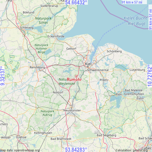
Rumohr GPS coordinates[2]
54° 15' 20.232" North, 10° 1' 28.164" East
| Map corner | latitude | longitude |
|---|---|---|
| Upper-left | 54.66432°, | 9.32137° |
| Center: | 54.25562°, | 10.02449° |
| Lower-right: | 53.84283°, | 10.72762° |
| Map W x H: | 91.3×91.3 km | = 56.7×56.7mi |
| max Lat: | 55.01917° ⇑4.2% North |
| Rumohr: | 54.25562° |
| min Lat: | ⇓95.8% South 47.40724° |
| min Long | Rumohr | max Long |
| 5.92978° | 10.02449° | 14.98853° |
| W 50.5%⇐ | ⇒49.5% E |
Elevation
Elevation of Rumohr is 27 m = 89 ft, and this is 222.1 m = 729 ft below average elevation for this country.
| Max E: |
1256 m = 4121 ft | 88% |
| Avg. | 249.1 m = 817 ft | |
| Rumohr | 27 m = 89 ft | |
Min E: |
-5 m = -16 ft | 12% |
See also: Germany elevation on elevation.city.
Geographical zone
Rumohr is located in North temperate zone (between Tropic of Cancer and the Arctic Circle). Distance of this North polar circle is 1368.5 km =850.3 mi to North.| Distance of | km | miles | from Rumohr |
|---|---|---|---|
| North Pole | 3974.4 | 2469.6 | to North |
| Arctic Circle | 1368.5 | 850.3 | to North |
| Tropic Cancer | 3426.7 | 2129.3 | to South |
| Equator | 6032.7 | 3748.5 | to South |


Nearby cities:
15 places around Rumohr: (largest is in red/bold)
• Achterwehr
7.4 km =4.6 mi,  329°
329°
• Blumenthal
2.9 km =1.8 mi,  212°
212°
• Böhnhusen
5.1 km =3.2 mi,  147°
147°
• Flintbek
2.8 km =1.7 mi,  102°
102°
• Grevenkrug
4.4 km =2.7 mi,  186°
186°
• Hoffeld
6.4 km =4 mi, 194°
• Klein Barkau
7.5 km =4.7 mi,  109°
109°
• Melsdorf
6.8 km =4.2 mi,  4°
4°
• Mielkendorf
3.5 km =2.2 mi,  28°
28°
• Molfsee
3 km =1.9 mi,  65°
65°
• Rodenbek
3.1 km =1.9 mi,  350°
350°
• Schierensee
2.7 km =1.7 mi,  256°
256°
• Schmalstede
6.2 km =3.9 mi,  174°
174°
• Sören
6.2 km =3.9 mi,  184°
184°
• Techelsdorf
4.6 km =2.9 mi,  159°
159°
Sources, notices
• [Note1] Compared only with cities in Germany existing in our database
• [Src1] Map data: © OpenStreetMap contributors (CC-BY-SA)
• [Src2] Other city data from geonames.org with taken over terms of usage.
• [Src3] Geographical zone / Annual Mean Temperature by Robert A. Rohde @ Wikipedia
