Techelsdorf geodata
Techelsdorf (Schleswig-Holstein) is a seat of a fourth-order administrative division; located in Germany in Europe/Berlin (GMT+2) time zone. With population of 163 people, there are 10625 cities with bigger population in this country. Compared to other cities in Germany, 95.3% of cities are located further ↓South; 50.8% of cities are located further ←West and 83.2% of cities have higher elevation than Techelsdorf. Note1
Administrative division(s):
- Level 1: Schleswig-Holstein
- Level 3: Kreis Rendsburg-Eckernförde
- Level 4: Techelsdorf


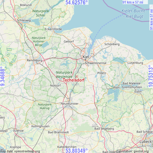
Techelsdorf GPS coordinates[2]
54° 13' 0.012" North, 10° 3' 0" East
| Map corner | latitude | longitude |
|---|---|---|
| Upper-left | 54.62576°, | 9.34688° |
| Center: | 54.21667°, | 10.05° |
| Lower-right: | 53.80349°, | 10.75313° |
| Map W x H: | 91.4×91.4 km | = 56.8×56.8mi |
| max Lat: | 55.01917° ⇑4.7% North |
| Techelsdorf: | 54.21667° |
| min Lat: | ⇓95.3% South 47.40724° |
| min Long | Techelsdorf | max Long |
| 5.92978° | 10.05° | 14.98853° |
| W 50.8%⇐ | ⇒49.2% E |
Elevation
Elevation of Techelsdorf is 39 m = 128 ft, and this is 210.1 m = 689 ft below average elevation for this country.
| Max E: |
1256 m = 4121 ft | 83.2% |
| Avg. | 249.1 m = 817 ft | |
| Techelsdorf | 39 m = 128 ft | |
Min E: |
-5 m = -16 ft | 16.8% |
See also: Germany elevation on elevation.city.
Geographical zone
Techelsdorf is located in North temperate zone (between Tropic of Cancer and the Arctic Circle). Distance of this North polar circle is 1372.8 km =853 mi to North.| Distance of | km | miles | from Techelsdorf |
|---|---|---|---|
| North Pole | 3978.7 | 2472.2 | to North |
| Arctic Circle | 1372.8 | 853 | to North |
| Tropic Cancer | 3422.4 | 2126.6 | to South |
| Equator | 6028.3 | 3745.8 | to South |


Nearby cities:
15 places around Techelsdorf: (largest is in red/bold)
• Blumenthal
3.7 km =2.3 mi,  299°
299°
• Boksee
5.7 km =3.5 mi,  71°
71°
• Bordesholm
4.7 km =2.9 mi,  194°
194°
• Brügge
4.7 km =2.9 mi,  164°
164°
• Böhnhusen
1.1 km =0.7 mi,  90°
90°
• Flintbek
3.9 km =2.4 mi,  16°
16°
• Grevenkrug
2.2 km =1.4 mi,  270°
270°
• Hoffeld
3.7 km =2.3 mi,  240°
240°
• Klein Barkau
5.7 km =3.5 mi, 71°
• Molfsee
5.7 km =3.5 mi,  11°
11°
• Reesdorf
3.7 km =2.3 mi,  180°
180°
• Rumohr
4.6 km =2.9 mi,  339°
339°
• Schmalstede
2.1 km =1.3 mi,  210°
210°
• Sören
2.9 km =1.8 mi,  229°
229°
• Wattenbek
5.6 km =3.5 mi, 180°
Sources, notices
• [Note1] Compared only with cities in Germany existing in our database
• [Src1] Map data: © OpenStreetMap contributors (CC-BY-SA)
• [Src2] Other city data from geonames.org with taken over terms of usage.
• [Src3] Geographical zone / Annual Mean Temperature by Robert A. Rohde @ Wikipedia
