Rivenich geodata
Rivenich (Rheinland-Pfalz) is a seat of a fourth-order administrative division; located in Germany in Europe/Berlin (GMT+2) time zone. With population of 736 people, there are 8166 cities with bigger population in this country. Compared to other cities in Germany, 67.1% of cities are located further ↑North; 95.2% of cities are located further →East and 62.3% of cities have higher elevation than Rivenich. Note1
Administrative division(s):
- Level 1: Rheinland-Pfalz
- Level 3: Landkreis Bernkastel-Wittlich
- Level 4: Rivenich


Rivenich GPS coordinates[2]
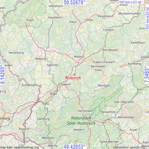
49° 52' 32.808" North, 6° 50' 42.612" East
| Map corner | latitude | longitude |
|---|---|---|
| Upper-left | 50.32678°, | 6.14205° |
| Center: | 49.87578°, | 6.84517° |
| Lower-right: | 49.42053°, | 7.5483° |
| Map W x H: | 100.8×100.8 km | = 62.6×62.6mi |
| max Lat: | 55.01917° ⇑67.1% North |
| Rivenich: | 49.87578° |
| min Lat: | ⇓32.9% South 47.40724° |
| min Long | Rivenich | max Long |
| 5.92978° | 6.84517° | 14.98853° |
| W 4.8%⇐ | ⇒95.2% E |
Elevation
Elevation of Rivenich is 136 m = 446 ft, and this is 113.1 m = 371 ft below average elevation for this country.
| Max E: |
1256 m = 4121 ft | 62.3% |
| Avg. | 249.1 m = 817 ft | |
| Rivenich | 136 m = 446 ft | |
Min E: |
-5 m = -16 ft | 37.7% |
See also: Germany elevation on elevation.city.
Geographical zone
Rivenich is located in North temperate zone (between Tropic of Cancer and the Arctic Circle). Distance of this North polar circle is 1855.5 km =1153 mi to North.| Distance of | km | miles | from Rivenich |
|---|---|---|---|
| North Pole | 4461.4 | 2772.2 | to North |
| Arctic Circle | 1855.5 | 1153 | to North |
| Tropic Cancer | 2939.7 | 1826.6 | to South |
| Equator | 5545.7 | 3445.9 | to South |


Nearby cities:
15 places around Rivenich: (largest is in red/bold)
• Bekond
4.3 km =2.7 mi,  228°
228°
• Dodenburg
6.3 km =3.9 mi,  315°
315°
• Ensch
5.5 km =3.4 mi,  189°
189°
• Esch
2.7 km =1.7 mi,  7°
7°
• Föhren
6 km =3.7 mi,  252°
252°
• Heckenmünster
5.2 km =3.2 mi,  301°
301°
• Hetzerath
2.2 km =1.4 mi,  292°
292°
• Klausen
3.8 km =2.4 mi,  45°
45°
• Klüsserath
3.4 km =2.1 mi,  173°
173°
• Köwerich
5.5 km =3.4 mi,  149°
149°
• Neumagen-Dhron
4.4 km =2.7 mi,  120°
120°
• Piesport
5.2 km =3.2 mi,  76°
76°
• Salmtal
6.4 km =4 mi,  3°
3°
• Sehlem
2.8 km =1.7 mi,  342°
342°
• Thörnich
4.6 km =2.9 mi, 186°
Sources, notices
• [Note1] Compared only with cities in Germany existing in our database
• [Src1] Map data: © OpenStreetMap contributors (CC-BY-SA)
• [Src2] Other city data from geonames.org with taken over terms of usage.
• [Src3] Geographical zone / Annual Mean Temperature by Robert A. Rohde @ Wikipedia
