Föhren geodata
Föhren (Rheinland-Pfalz) is a seat of a fourth-order administrative division; located in Germany in Europe/Berlin (GMT+2) time zone. With population of 2,649 people, there are 4284 cities with bigger population in this country. Compared to other cities in Germany, 67.6% of cities are located further ↑North; 95.9% of cities are located further →East and 54.6% of cities have higher elevation than Föhren. Note1
Administrative division(s):
- Level 1: Rheinland-Pfalz
- Level 3: Landkreis Trier-Saarburg
- Level 4: Föhren


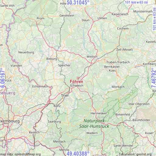
Föhren GPS coordinates[2]
49° 51' 33.444" North, 6° 45' 53.28" East
| Map corner | latitude | longitude |
|---|---|---|
| Upper-left | 50.31045°, | 6.06167° |
| Center: | 49.85929°, | 6.7648° |
| Lower-right: | 49.40388°, | 7.46792° |
| Map W x H: | 100.8×100.8 km | = 62.6×62.6mi |
| max Lat: | 55.01917° ⇑67.6% North |
| Föhren: | 49.85929° |
| min Lat: | ⇓32.4% South 47.40724° |
| min Long | Föhren | max Long |
| 5.92978° | 6.7648° | 14.98853° |
| W 4.1%⇐ | ⇒95.9% E |
Elevation
Elevation of Föhren is 192 m = 630 ft, and this is 57.1 m = 187 ft below average elevation for this country.
| Max E: |
1256 m = 4121 ft | 54.6% |
| Avg. | 249.1 m = 817 ft | |
| Föhren | 192 m = 630 ft | |
Min E: |
-5 m = -16 ft | 45.4% |
See also: Germany elevation on elevation.city.
Geographical zone
Föhren is located in North temperate zone (between Tropic of Cancer and the Arctic Circle). Distance of this North polar circle is 1857.3 km =1154.1 mi to North.| Distance of | km | miles | from Föhren |
|---|---|---|---|
| North Pole | 4463.2 | 2773.3 | to North |
| Arctic Circle | 1857.3 | 1154.1 | to North |
| Tropic Cancer | 2937.9 | 1825.5 | to South |
| Equator | 5543.8 | 3444.8 | to South |


Nearby cities:
15 places around Föhren: (largest is in red/bold)
• Bekond
2.7 km =1.7 mi,  112°
112°
• Dierscheid
4.3 km =2.7 mi,  354°
354°
• Dodenburg
6.5 km =4 mi,  11°
11°
• Ensch
6 km =3.7 mi,  126°
126°
• Heckenmünster
4.7 km =2.9 mi,  16°
16°
• Heidweiler
6.5 km =4 mi, 350°
• Hetzerath
4.6 km =2.9 mi,  54°
54°
• Klüsserath
6.4 km =4 mi,  104°
104°
• Longen
6.7 km =4.2 mi,  168°
168°
• Longuich
5.7 km =3.5 mi,  177°
177°
• Rivenich
6 km =3.7 mi,  72°
72°
• Schweich
4.2 km =2.6 mi,  191°
191°
• Sehlem
6.7 km =4.2 mi, 47°
• Thörnich
6 km =3.7 mi,  117°
117°
• Zemmer
6.5 km =4 mi,  314°
314°
Sources, notices
• [Note1] Compared only with cities in Germany existing in our database
• [Src1] Map data: © OpenStreetMap contributors (CC-BY-SA)
• [Src2] Other city data from geonames.org with taken over terms of usage.
• [Src3] Geographical zone / Annual Mean Temperature by Robert A. Rohde @ Wikipedia
