Ritzerau geodata
Ritzerau (Schleswig-Holstein) is a seat of a fourth-order administrative division; located in Germany in Europe/Berlin (GMT+2) time zone. With population of 316 people, there are 9998 cities with bigger population in this country. Compared to other cities in Germany, 88% of cities are located further ↓South; 60.1% of cities are located further ←West and 83.2% of cities have higher elevation than Ritzerau. Note1
Administrative division(s):
- Level 1: Schleswig-Holstein
- Level 3: Kreis Herzogtum Lauenburg
- Level 4: Ritzerau


Ritzerau GPS coordinates[2]
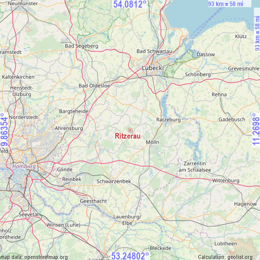
53° 40' 0.012" North, 10° 34' 0.012" East
| Map corner | latitude | longitude |
|---|---|---|
| Upper-left | 54.0812°, | 9.86354° |
| Center: | 53.66667°, | 10.56667° |
| Lower-right: | 53.24802°, | 11.2698° |
| Map W x H: | 92.6×92.6 km | = 57.5×57.5mi |
| max Lat: | 55.01917° ⇑12% North |
| Ritzerau: | 53.66667° |
| min Lat: | ⇓88% South 47.40724° |
| min Long | Ritzerau | max Long |
| 5.92978° | 10.56667° | 14.98853° |
| W 60.1%⇐ | ⇒39.9% E |
Elevation
Elevation of Ritzerau is 39 m = 128 ft, and this is 210.1 m = 689 ft below average elevation for this country.
| Max E: |
1256 m = 4121 ft | 83.2% |
| Avg. | 249.1 m = 817 ft | |
| Ritzerau | 39 m = 128 ft | |
Min E: |
-5 m = -16 ft | 16.8% |
See also: Germany elevation on elevation.city.
Geographical zone
Ritzerau is located in North temperate zone (between Tropic of Cancer and the Arctic Circle). Distance of this North polar circle is 1434 km =891 mi to North.| Distance of | km | miles | from Ritzerau |
|---|---|---|---|
| North Pole | 4039.9 | 2510.3 | to North |
| Arctic Circle | 1434 | 891 | to North |
| Tropic Cancer | 3361.3 | 2088.6 | to South |
| Equator | 5967.2 | 3707.8 | to South |


Nearby cities:
15 places around Ritzerau: (largest is in red/bold)
• Borstorf
5.6 km =3.5 mi,  180°
180°
• Bälau
6.5 km =4 mi,  149°
149°
• Duvensee
3.7 km =2.3 mi,  0°
0°
• Klinkrade
5.7 km =3.5 mi,  348°
348°
• Koberg
4.6 km =2.9 mi,  217°
217°
• Kühsen
3.8 km =2.4 mi,  60°
60°
• Labenz
5.6 km =3.5 mi,  328°
328°
• Lüchow
2.9 km =1.8 mi,  310°
310°
• Nusse
1.6 km =1 mi,  134°
134°
• Panten
3.3 km =2.1 mi,  90°
90°
• Poggensee
2.2 km =1.4 mi, 149°
• Sandesneben
4.8 km =3 mi,  292°
292°
• Sirksfelde
4.4 km =2.7 mi,  270°
270°
• Walksfelde
3.9 km =2.4 mi,  163°
163°
• Wentorf
6.2 km =3.9 mi,  278°
278°
Sources, notices
• [Note1] Compared only with cities in Germany existing in our database
• [Src1] Map data: © OpenStreetMap contributors (CC-BY-SA)
• [Src2] Other city data from geonames.org with taken over terms of usage.
• [Src3] Geographical zone / Annual Mean Temperature by Robert A. Rohde @ Wikipedia
