Poggensee geodata
Poggensee (Schleswig-Holstein) is a seat of a fourth-order administrative division; located in Germany in Europe/Berlin (GMT+2) time zone. With population of 354 people, there are 9864 cities with bigger population in this country. Compared to other cities in Germany, 87.7% of cities are located further ↓South; 60.4% of cities are located further ←West and 78.7% of cities have higher elevation than Poggensee. Note1
Administrative division(s):
- Level 1: Schleswig-Holstein
- Level 3: Kreis Herzogtum Lauenburg
- Level 4: Poggensee


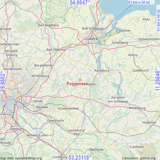
Poggensee GPS coordinates[2]
53° 39' 0" North, 10° 34' 59.988" East
| Map corner | latitude | longitude |
|---|---|---|
| Upper-left | 54.0647°, | 9.8802° |
| Center: | 53.65°, | 10.58333° |
| Lower-right: | 53.23118°, | 11.28646° |
| Map W x H: | 92.7×92.7 km | = 57.6×57.6mi |
| max Lat: | 55.01917° ⇑12.3% North |
| Poggensee: | 53.65° |
| min Lat: | ⇓87.7% South 47.40724° |
| min Long | Poggensee | max Long |
| 5.92978° | 10.58333° | 14.98853° |
| W 60.4%⇐ | ⇒39.6% E |
Elevation
Elevation of Poggensee is 51 m = 167 ft, and this is 198.1 m = 650 ft below average elevation for this country.
| Max E: |
1256 m = 4121 ft | 78.7% |
| Avg. | 249.1 m = 817 ft | |
| Poggensee | 51 m = 167 ft | |
Min E: |
-5 m = -16 ft | 21.3% |
See also: Germany elevation on elevation.city.
Geographical zone
Poggensee is located in North temperate zone (between Tropic of Cancer and the Arctic Circle). Distance of this North polar circle is 1435.9 km =892.2 mi to North.| Distance of | km | miles | from Poggensee |
|---|---|---|---|
| North Pole | 4041.7 | 2511.4 | to North |
| Arctic Circle | 1435.9 | 892.2 | to North |
| Tropic Cancer | 3359.4 | 2087.4 | to South |
| Equator | 5965.3 | 3706.7 | to South |


Nearby cities:
15 places around Poggensee: (largest is in red/bold)
• Alt Mölln
6 km =3.7 mi,  119°
119°
• Borstorf
3.9 km =2.4 mi,  196°
196°
• Breitenfelde
5.9 km =3.7 mi,  146°
146°
• Bälau
4.3 km =2.7 mi, 149°
• Duvensee
5.7 km =3.5 mi,  348°
348°
• Koberg
4.3 km =2.7 mi,  245°
245°
• Kühsen
4.3 km =2.7 mi,  30°
30°
• Lankau
5.8 km =3.6 mi,  71°
71°
• Lüchow
5 km =3.1 mi,  318°
318°
• Nusse
0.7 km =0.4 mi,  3°
3°
• Panten
2.9 km =1.8 mi,  49°
49°
• Ritzerau
2.2 km =1.4 mi,  329°
329°
• Sandesneben
6.6 km =4.1 mi,  304°
304°
• Sirksfelde
5.8 km =3.6 mi,  288°
288°
• Walksfelde
1.9 km =1.2 mi,  180°
180°
Sources, notices
• [Note1] Compared only with cities in Germany existing in our database
• [Src1] Map data: © OpenStreetMap contributors (CC-BY-SA)
• [Src2] Other city data from geonames.org with taken over terms of usage.
• [Src3] Geographical zone / Annual Mean Temperature by Robert A. Rohde @ Wikipedia
