Rechtenstein geodata
Rechtenstein (Baden-Württemberg) is a seat of a fourth-order administrative division; located in Germany in Europe/Berlin (GMT+2) time zone. With population of 300 people, there are 10048 cities with bigger population in this country. Compared to other cities in Germany, 92.1% of cities are located further ↑North; 57.1% of cities are located further →East and 91.1% of cities have lower elevation than Rechtenstein. Note1
Administrative division(s):
- Level 1: Baden-Württemberg
- Level 2: Tübingen Region
- Level 3: Alb-Donau-Kreis
- Level 4: Rechtenstein


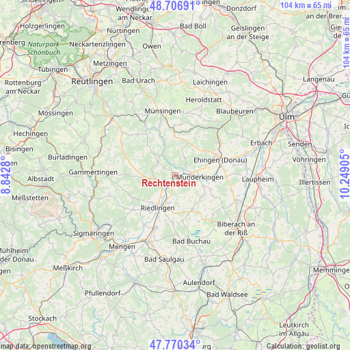
Rechtenstein GPS coordinates[2]
48° 14' 26.772" North, 9° 32' 45.312" East
| Map corner | latitude | longitude |
|---|---|---|
| Upper-left | 48.70691°, | 8.8428° |
| Center: | 48.24077°, | 9.54592° |
| Lower-right: | 47.77034°, | 10.24905° |
| Map W x H: | 104.1×104.1 km | = 64.7×64.7mi |
| max Lat: | 55.01917° ⇑92.1% North |
| Rechtenstein: | 48.24077° |
| min Lat: | ⇓7.9% South 47.40724° |
| min Long | Rechtenstein | max Long |
| 5.92978° | 9.54592° | 14.98853° |
| W 42.9%⇐ | ⇒57.1% E |
Elevation
Elevation of Rechtenstein is 529 m = 1736 ft, and this is 279.9 m = 918 ft above average elevation for this country.
| Max E: |
1256 m = 4121 ft | 8.9% |
| Rechtenstein | 529 m 1736 ft | |
| Avg. | 249.1 m = 817 ft | |
Min E: |
-5 m = -16 ft | 91.1% |
See also: Germany elevation on elevation.city.
Geographical zone
Rechtenstein is located in North temperate zone (between Tropic of Cancer and the Arctic Circle). Distance of this North polar circle is 2037.3 km =1265.9 mi to North.| Distance of | km | miles | from Rechtenstein |
|---|---|---|---|
| North Pole | 4643.2 | 2885.1 | to North |
| Arctic Circle | 2037.3 | 1265.9 | to North |
| Tropic Cancer | 2758 | 1713.7 | to South |
| Equator | 5363.9 | 3333 | to South |


Nearby cities:
15 places around Rechtenstein: (largest is in red/bold)
• Emeringen
2.2 km =1.4 mi,  249°
249°
• Emerkingen
8.8 km =5.5 mi,  111°
111°
• Hausen am Bussen
6.7 km =4.2 mi,  118°
118°
• Hayingen
6.4 km =4 mi,  307°
307°
• Lauterach
3.1 km =1.9 mi,  56°
56°
• Munderkingen
7.3 km =4.5 mi,  94°
94°
• Obermarchtal
2.1 km =1.3 mi, 114°
• Riedlingen
10.9 km =6.8 mi,  208°
208°
• Rottenacker
10.7 km =6.6 mi, 93°
• Unlingen
8.4 km =5.2 mi,  192°
192°
• Untermarchtal
4.7 km =2.9 mi, 92°
• Unterstadion
11.4 km =7.1 mi, 111°
• Unterwachingen
8.4 km =5.2 mi, 120°
• Uttenweiler
11.4 km =7.1 mi,  152°
152°
• Zwiefalten
6.2 km =3.9 mi,  263°
263°
Sources, notices
• [Note1] Compared only with cities in Germany existing in our database
• [Src1] Map data: © OpenStreetMap contributors (CC-BY-SA)
• [Src2] Other city data from geonames.org with taken over terms of usage.
• [Src3] Geographical zone / Annual Mean Temperature by Robert A. Rohde @ Wikipedia
