Unterstadion geodata
Unterstadion (Baden-Württemberg) is a seat of a fourth-order administrative division; located in Germany in Europe/Berlin (GMT+2) time zone. With population of 760 people, there are 8050 cities with bigger population in this country. Compared to other cities in Germany, 92.6% of cities are located further ↑North; 54.5% of cities are located further →East and 89% of cities have lower elevation than Unterstadion. Note1
Administrative division(s):
- Level 1: Baden-Württemberg
- Level 2: Tübingen Region
- Level 3: Alb-Donau-Kreis
- Level 4: Unterstadion


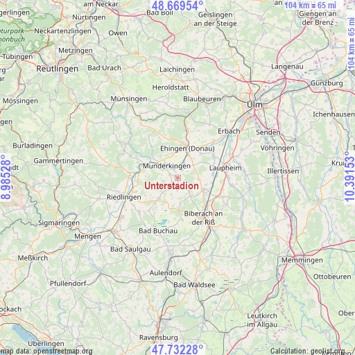
Unterstadion GPS coordinates[2]
48° 12' 10.98" North, 9° 41' 18.24" East
| Map corner | latitude | longitude |
|---|---|---|
| Upper-left | 48.66954°, | 8.98528° |
| Center: | 48.20305°, | 9.6884° |
| Lower-right: | 47.73228°, | 10.39153° |
| Map W x H: | 104.2×104.2 km | = 64.7×64.7mi |
| max Lat: | 55.01917° ⇑92.6% North |
| Unterstadion: | 48.20305° |
| min Lat: | ⇓7.4% South 47.40724° |
| min Long | Unterstadion | max Long |
| 5.92978° | 9.6884° | 14.98853° |
| W 45.5%⇐ | ⇒54.5% E |
Elevation
Elevation of Unterstadion is 504 m = 1654 ft, and this is 254.9 m = 836 ft above average elevation for this country.
| Max E: |
1256 m = 4121 ft | 11% |
| Unterstadion | 504 m 1654 ft | |
| Avg. | 249.1 m = 817 ft | |
Min E: |
-5 m = -16 ft | 89% |
See also: Germany elevation on elevation.city.
Geographical zone
Unterstadion is located in North temperate zone (between Tropic of Cancer and the Arctic Circle). Distance of this North polar circle is 2041.5 km =1268.5 mi to North.| Distance of | km | miles | from Unterstadion |
|---|---|---|---|
| North Pole | 4647.4 | 2887.8 | to North |
| Arctic Circle | 2041.5 | 1268.5 | to North |
| Tropic Cancer | 2753.8 | 1711.1 | to South |
| Equator | 5359.7 | 3330.4 | to South |


Nearby cities:
15 places around Unterstadion: (largest is in red/bold)
• Attenweiler
7.8 km =4.8 mi,  173°
173°
• Dettingen
7 km =4.3 mi,  20°
20°
• Ehingen
9.3 km =5.8 mi, 18°
• Emerkingen
2.6 km =1.6 mi,  292°
292°
• Griesingen
10 km =6.2 mi,  44°
44°
• Grundsheim
4.4 km =2.7 mi,  201°
201°
• Hausen am Bussen
4.8 km =3 mi,  281°
281°
• Lauterach
9.9 km =6.2 mi,  306°
306°
• Munderkingen
4.9 km =3 mi,  317°
317°
• Obermarchtal
9.2 km =5.7 mi, 291°
• Oberstadion
1.9 km =1.2 mi, 171°
• Rottenacker
3.5 km =2.2 mi,  1°
1°
• Untermarchtal
7.1 km =4.4 mi,  304°
304°
• Unterwachingen
3.3 km =2.1 mi,  269°
269°
• Uttenweiler
7.9 km =4.9 mi,  222°
222°
Sources, notices
• [Note1] Compared only with cities in Germany existing in our database
• [Src1] Map data: © OpenStreetMap contributors (CC-BY-SA)
• [Src2] Other city data from geonames.org with taken over terms of usage.
• [Src3] Geographical zone / Annual Mean Temperature by Robert A. Rohde @ Wikipedia
