Quenstedt geodata
Quenstedt (Saxony-Anhalt) is a populated place; located in Germany in Europe/Berlin (GMT+2) time zone. With population of 883 people, there are 7580 cities with bigger population in this country. Compared to other cities in Germany, 68.9% of cities are located further ↓South; 73.6% of cities are located further ←West and 55.1% of cities have higher elevation than Quenstedt. Note1


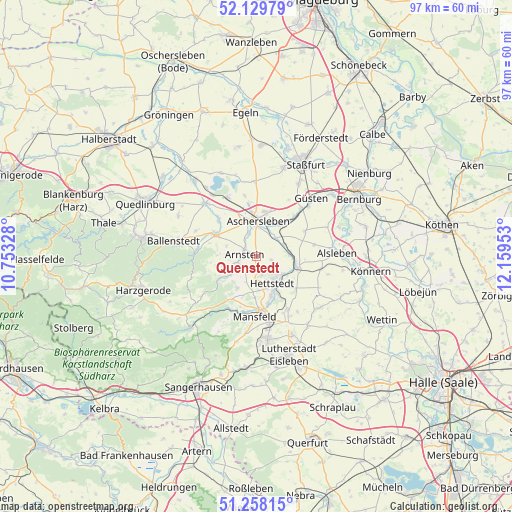
Quenstedt GPS coordinates[2]
51° 41' 45.852" North, 11° 27' 23.04" East
| Map corner | latitude | longitude |
|---|---|---|
| Upper-left | 52.12979°, | 10.75328° |
| Center: | 51.69607°, | 11.4564° |
| Lower-right: | 51.25815°, | 12.15953° |
| Map W x H: | 96.9×96.9 km | = 60.2×60.2mi |
| max Lat: | 55.01917° ⇑31.1% North |
| Quenstedt: | 51.69607° |
| min Lat: | ⇓68.9% South 47.40724° |
| min Long | Quenstedt | max Long |
| 5.92978° | 11.4564° | 14.98853° |
| W 73.6%⇐ | ⇒26.4% E |
Elevation
Elevation of Quenstedt is 187 m = 614 ft, and this is 62.1 m = 204 ft below average elevation for this country.
| Max E: |
1256 m = 4121 ft | 55.1% |
| Avg. | 249.1 m = 817 ft | |
| Quenstedt | 187 m = 614 ft | |
Min E: |
-5 m = -16 ft | 44.9% |
See also: Germany elevation on elevation.city.
Geographical zone
Quenstedt is located in North temperate zone (between Tropic of Cancer and the Arctic Circle). Distance of this North polar circle is 1653.1 km =1027.2 mi to North.| Distance of | km | miles | from Quenstedt |
|---|---|---|---|
| North Pole | 4259 | 2646.4 | to North |
| Arctic Circle | 1653.1 | 1027.2 | to North |
| Tropic Cancer | 3142.1 | 1952.4 | to South |
| Equator | 5748.1 | 3571.7 | to South |


Nearby cities:
15 places around Quenstedt: (largest is in red/bold)
• Alterode
5.5 km =3.4 mi,  245°
245°
• Arnstedt
3 km =1.9 mi,  104°
104°
• Aschersleben
6.8 km =4.2 mi,  2°
2°
• Bräunrode
7 km =4.3 mi,  210°
210°
• Drohndorf
5.7 km =3.5 mi,  65°
65°
• Freckleben
6.2 km =3.9 mi,  84°
84°
• Groß-Schierstedt
7.3 km =4.5 mi,  37°
37°
• Hettstedt
6.3 km =3.9 mi,  143°
143°
• Mehringen
5.2 km =3.2 mi,  48°
48°
• Sandersleben
8 km =5 mi,  105°
105°
• Sylda
2.9 km =1.8 mi,  227°
227°
• Walbeck
3.6 km =2.2 mi,  164°
164°
• Welbsleben
2.6 km =1.6 mi,  298°
298°
• Westdorf
4.6 km =2.9 mi,  341°
341°
• Wiederstedt
6 km =3.7 mi,  125°
125°
Sources, notices
• [Note1] Compared only with cities in Germany existing in our database
• [Src1] Map data: © OpenStreetMap contributors (CC-BY-SA)
• [Src2] Other city data from geonames.org with taken over terms of usage.
• [Src3] Geographical zone / Annual Mean Temperature by Robert A. Rohde @ Wikipedia
