Bräunrode geodata
Bräunrode (Saxony-Anhalt) is a populated place; located in Germany in Europe/Berlin (GMT+2) time zone. With population of 541 people, there are 9136 cities with bigger population in this country. Compared to other cities in Germany, 68.2% of cities are located further ↓South; 72.7% of cities are located further ←West and 57.5% of cities have lower elevation than Bräunrode. Note1


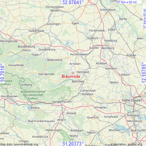
Bräunrode GPS coordinates[2]
51° 38' 31.812" North, 11° 24' 16.992" East
| Map corner | latitude | longitude |
|---|---|---|
| Upper-left | 52.07641°, | 10.7016° |
| Center: | 51.64217°, | 11.40472° |
| Lower-right: | 51.20373°, | 12.10785° |
| Map W x H: | 97×97 km | = 60.3×60.3mi |
| max Lat: | 55.01917° ⇑31.8% North |
| Bräunrode: | 51.64217° |
| min Lat: | ⇓68.2% South 47.40724° |
| min Long | Bräunrode | max Long |
| 5.92978° | 11.40472° | 14.98853° |
| W 72.7%⇐ | ⇒27.3% E |
Elevation
Elevation of Bräunrode is 275 m = 902 ft, and this is 25.9 m = 85 ft above average elevation for this country.
| Max E: |
1256 m = 4121 ft | 42.5% |
| Bräunrode | 275 m 902 ft | |
| Avg. | 249.1 m = 817 ft | |
Min E: |
-5 m = -16 ft | 57.5% |
See also: Germany elevation on elevation.city.
Geographical zone
Bräunrode is located in North temperate zone (between Tropic of Cancer and the Arctic Circle). Distance of this North polar circle is 1659.1 km =1030.9 mi to North.| Distance of | km | miles | from Bräunrode |
|---|---|---|---|
| North Pole | 4265 | 2650.1 | to North |
| Arctic Circle | 1659.1 | 1030.9 | to North |
| Tropic Cancer | 3136.2 | 1948.7 | to South |
| Equator | 5742.1 | 3568 | to South |


Nearby cities:
15 places around Bräunrode: (largest is in red/bold)
• Alterode
4 km =2.5 mi,  338°
338°
• Annarode
10.2 km =6.3 mi,  180°
180°
• Arnstedt
8.3 km =5.2 mi,  51°
51°
• Benndorf
10 km =6.2 mi,  142°
142°
• Großörner
6.6 km =4.1 mi,  116°
116°
• Hettstedt
7.4 km =4.6 mi,  83°
83°
• Klostermansfeld
9.3 km =5.8 mi,  134°
134°
• Mansfeld
6.4 km =4 mi,  149°
149°
• Quenstedt
7 km =4.3 mi,  30°
30°
• Siebigerode
8.8 km =5.5 mi,  169°
169°
• Sylda
4.3 km =2.7 mi,  19°
19°
• Vatterode
5.1 km =3.2 mi,  158°
158°
• Walbeck
5.2 km =3.2 mi,  60°
60°
• Welbsleben
7.3 km =4.5 mi,  10°
10°
• Wiederstedt
8.8 km =5.5 mi,  73°
73°
Sources, notices
• [Note1] Compared only with cities in Germany existing in our database
• [Src1] Map data: © OpenStreetMap contributors (CC-BY-SA)
• [Src2] Other city data from geonames.org with taken over terms of usage.
• [Src3] Geographical zone / Annual Mean Temperature by Robert A. Rohde @ Wikipedia
