Prüm geodata
Prüm (Rheinland-Pfalz) is a populated place; located in Germany in Europe/Berlin (GMT+2) time zone. With population of 5,471 people, there are 2638 cities with bigger population in this country. Compared to other cities in Germany, 58.9% of cities are located further ↑North; 98.4% of cities are located further →East and 84.1% of cities have lower elevation than Prüm. Note1


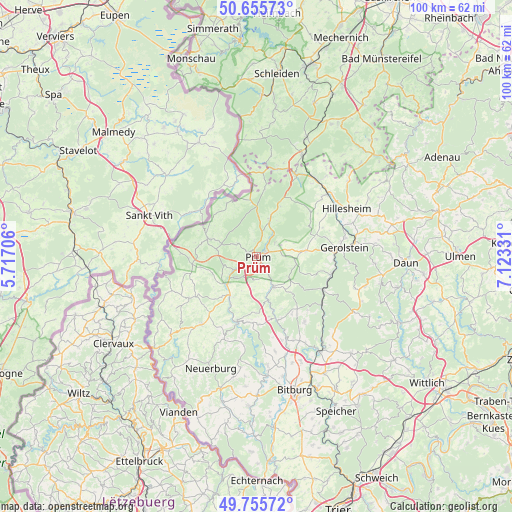
Prüm GPS coordinates[2]
50° 12' 28.26" North, 6° 25' 12.684" East
| Map corner | latitude | longitude |
|---|---|---|
| Upper-left | 50.65573°, | 5.71706° |
| Center: | 50.20785°, | 6.42019° |
| Lower-right: | 49.75572°, | 7.12331° |
| Map W x H: | 100.1×100.1 km | = 62.2×62.2mi |
| max Lat: | 55.01917° ⇑58.9% North |
| Prüm: | 50.20785° |
| min Lat: | ⇓41.1% South 47.40724° |
| min Long | Prüm | max Long |
| 5.92978° | 6.42019° | 14.98853° |
| W 1.6%⇐ | ⇒98.4% E |
Elevation
Elevation of Prüm is 462 m = 1516 ft, and this is 212.9 m = 698 ft above average elevation for this country.
| Max E: |
1256 m = 4121 ft | 15.9% |
| Prüm | 462 m 1516 ft | |
| Avg. | 249.1 m = 817 ft | |
Min E: |
-5 m = -16 ft | 84.1% |
See also: Germany elevation on elevation.city.
Geographical zone
Prüm is located in North temperate zone (between Tropic of Cancer and the Arctic Circle). Distance of this North polar circle is 1818.6 km =1130 mi to North.| Distance of | km | miles | from Prüm |
|---|---|---|---|
| North Pole | 4424.5 | 2749.3 | to North |
| Arctic Circle | 1818.6 | 1130 | to North |
| Tropic Cancer | 2976.7 | 1849.6 | to South |
| Equator | 5582.6 | 3468.9 | to South |


Nearby cities:
15 places around Prüm: (largest is in red/bold)
• Dingdorf
6.5 km =4 mi,  171°
171°
• Fleringen
5.8 km =3.6 mi,  80°
80°
• Giesdorf
3.5 km =2.2 mi,  142°
142°
• Gondenbrett
2.8 km =1.7 mi,  354°
354°
• Matzerath
6.9 km =4.3 mi,  202°
202°
• Niederlauch
4.7 km =2.9 mi, 168°
• Oberlauch
4.6 km =2.9 mi,  183°
183°
• Orlenbach
5.3 km =3.3 mi,  209°
209°
• Pittenbach
5.7 km =3.5 mi,  241°
241°
• Rommersheim
2.3 km =1.4 mi,  112°
112°
• Schönecken
6.4 km =4 mi,  147°
147°
• Sellerich
4.7 km =2.9 mi,  306°
306°
• Watzerath
4.7 km =2.9 mi,  234°
234°
• Weinsheim
4.4 km =2.7 mi,  49°
49°
• Winringen
6.4 km =4 mi, 182°
Sources, notices
• [Note1] Compared only with cities in Germany existing in our database
• [Src1] Map data: © OpenStreetMap contributors (CC-BY-SA)
• [Src2] Other city data from geonames.org with taken over terms of usage.
• [Src3] Geographical zone / Annual Mean Temperature by Robert A. Rohde @ Wikipedia
