Oberlauch geodata
Oberlauch (Rheinland-Pfalz) is a seat of a fourth-order administrative division; located in Germany in Europe/Berlin (GMT+2) time zone. With population of 67 people, there are 10927 cities with bigger population in this country. Compared to other cities in Germany, 59.7% of cities are located further ↑North; 98.5% of cities are located further →East and 92.6% of cities have lower elevation than Oberlauch. Note1
Administrative division(s):
- Level 1: Rheinland-Pfalz
- Level 3: Eifelkreis Bitburg-Prüm
- Level 4: Oberlauch


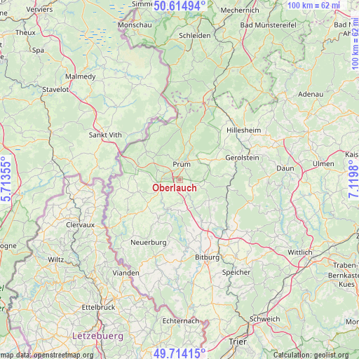
Oberlauch GPS coordinates[2]
50° 10' 0.012" North, 6° 25' 0.012" East
| Map corner | latitude | longitude |
|---|---|---|
| Upper-left | 50.61494°, | 5.71355° |
| Center: | 50.16667°, | 6.41667° |
| Lower-right: | 49.71415°, | 7.1198° |
| Map W x H: | 100.2×100.2 km | = 62.3×62.3mi |
| max Lat: | 55.01917° ⇑59.7% North |
| Oberlauch: | 50.16667° |
| min Lat: | ⇓40.3% South 47.40724° |
| min Long | Oberlauch | max Long |
| 5.92978° | 6.41667° | 14.98853° |
| W 1.5%⇐ | ⇒98.5% E |
Elevation
Elevation of Oberlauch is 552 m = 1811 ft, and this is 302.9 m = 994 ft above average elevation for this country.
| Max E: |
1256 m = 4121 ft | 7.4% |
| Oberlauch | 552 m 1811 ft | |
| Avg. | 249.1 m = 817 ft | |
Min E: |
-5 m = -16 ft | 92.6% |
See also: Germany elevation on elevation.city.
Geographical zone
Oberlauch is located in North temperate zone (between Tropic of Cancer and the Arctic Circle). Distance of this North polar circle is 1823.2 km =1132.9 mi to North.| Distance of | km | miles | from Oberlauch |
|---|---|---|---|
| North Pole | 4429.1 | 2752.1 | to North |
| Arctic Circle | 1823.2 | 1132.9 | to North |
| Tropic Cancer | 2972.1 | 1846.8 | to South |
| Equator | 5578 | 3466 | to South |


Nearby cities:
15 places around Oberlauch: (largest is in red/bold)
• Dingdorf
2.2 km =1.4 mi,  147°
147°
• Eilscheid
4.4 km =2.7 mi,  212°
212°
• Giesdorf
3 km =1.9 mi,  52°
52°
• Heisdorf
3.9 km =2.4 mi,  162°
162°
• Lierfeld
5.1 km =3.2 mi,  223°
223°
• Matzerath
3 km =1.9 mi,  232°
232°
• Niederlauch
1.2 km =0.7 mi,  90°
90°
• Nimsreuland
4.4 km =2.7 mi, 147°
• Orlenbach
2.4 km =1.5 mi,  270°
270°
• Pittenbach
5.1 km =3.2 mi,  291°
291°
• Prüm
4.6 km =2.9 mi,  3°
3°
• Rommersheim
4.4 km =2.7 mi,  32°
32°
• Schönecken
3.8 km =2.4 mi,  102°
102°
• Watzerath
4 km =2.5 mi,  297°
297°
• Winringen
1.9 km =1.2 mi,  180°
180°
Sources, notices
• [Note1] Compared only with cities in Germany existing in our database
• [Src1] Map data: © OpenStreetMap contributors (CC-BY-SA)
• [Src2] Other city data from geonames.org with taken over terms of usage.
• [Src3] Geographical zone / Annual Mean Temperature by Robert A. Rohde @ Wikipedia
