Ottendorf geodata
Ottendorf (Thuringia) is a seat of a fourth-order administrative division; located in Germany in Europe/Berlin (GMT+2) time zone. With population of 429 people, there are 9604 cities with bigger population in this country. Compared to other cities in Germany, 54.7% of cities are located further ↓South; 79.2% of cities are located further ←West and 52.9% of cities have lower elevation than Ottendorf. Note1


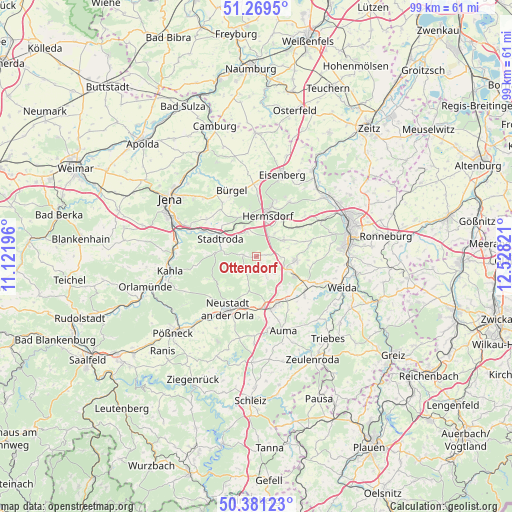
Ottendorf GPS coordinates[2]
50° 49' 38.928" North, 11° 49' 30.288" East
| Map corner | latitude | longitude |
|---|---|---|
| Upper-left | 51.2695°, | 11.12196° |
| Center: | 50.82748°, | 11.82508° |
| Lower-right: | 50.38123°, | 12.52821° |
| Map W x H: | 98.8×98.8 km | = 61.4×61.4mi |
| max Lat: | 55.01917° ⇑45.3% North |
| Ottendorf: | 50.82748° |
| min Lat: | ⇓54.7% South 47.40724° |
| min Long | Ottendorf | max Long |
| 5.92978° | 11.82508° | 14.98853° |
| W 79.2%⇐ | ⇒20.8% E |
Elevation
Elevation of Ottendorf is 246 m = 807 ft, and this is 3.1 m = 10 ft below average elevation for this country.
| Max E: |
1256 m = 4121 ft | 47.1% |
| Avg. | 249.1 m = 817 ft | |
| Ottendorf | 246 m = 807 ft | |
Min E: |
-5 m = -16 ft | 52.9% |
See also: Germany elevation on elevation.city.
Geographical zone
Ottendorf is located in North temperate zone (between Tropic of Cancer and the Arctic Circle). Distance of this North polar circle is 1749.7 km =1087.2 mi to North.| Distance of | km | miles | from Ottendorf |
|---|---|---|---|
| North Pole | 4355.6 | 2706.4 | to North |
| Arctic Circle | 1749.7 | 1087.2 | to North |
| Tropic Cancer | 3045.6 | 1892.4 | to South |
| Equator | 5651.5 | 3511.7 | to South |


Nearby cities:
15 places around Ottendorf: (largest is in red/bold)
• Bremsnitz
4.9 km =3 mi,  230°
230°
• Eineborn
3 km =1.9 mi,  77°
77°
• Karlsdorf
3.5 km =2.2 mi,  209°
209°
• Kleinebersdorf
1.3 km =0.8 mi,  154°
154°
• Möckern
4.8 km =3 mi,  301°
301°
• Mörsdorf
5.1 km =3.2 mi,  338°
338°
• Rattelsdorf
4.3 km =2.7 mi,  253°
253°
• Reichenbach
5.9 km =3.7 mi,  39°
39°
• Renthendorf
3.4 km =2.1 mi, 153°
• Sankt Gangloff
5.8 km =3.6 mi,  57°
57°
• Schwarzbach
4.9 km =3 mi,  133°
133°
• Tautendorf
5.4 km =3.4 mi,  102°
102°
• Tissa
5.8 km =3.6 mi, 295°
• Waltersdorf
5.3 km =3.3 mi,  277°
277°
• Weißbach
3.2 km =2 mi, 247°
Sources, notices
• [Note1] Compared only with cities in Germany existing in our database
• [Src1] Map data: © OpenStreetMap contributors (CC-BY-SA)
• [Src2] Other city data from geonames.org with taken over terms of usage.
• [Src3] Geographical zone / Annual Mean Temperature by Robert A. Rohde @ Wikipedia
