Kleinebersdorf geodata
Kleinebersdorf (Thuringia) is a seat of a fourth-order administrative division; located in Germany in Europe/Berlin (GMT+2) time zone. With population of 186 people, there are 10537 cities with bigger population in this country. Compared to other cities in Germany, 54.4% of cities are located further ↓South; 79.3% of cities are located further ←West and 60.2% of cities have lower elevation than Kleinebersdorf. Note1
Administrative division(s):
- Level 1: Thuringia
- Level 3: Saale-Holzland-Kreis
- Level 4: Kleinebersdorf


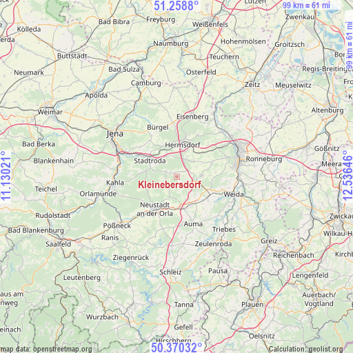
Kleinebersdorf GPS coordinates[2]
50° 49' 0.012" North, 11° 49' 59.988" East
| Map corner | latitude | longitude |
|---|---|---|
| Upper-left | 51.2588°, | 11.13021° |
| Center: | 50.81667°, | 11.83333° |
| Lower-right: | 50.37032°, | 12.53646° |
| Map W x H: | 98.8×98.8 km | = 61.4×61.4mi |
| max Lat: | 55.01917° ⇑45.6% North |
| Kleinebersdorf: | 50.81667° |
| min Lat: | ⇓54.4% South 47.40724° |
| min Long | Kleinebersdorf | max Long |
| 5.92978° | 11.83333° | 14.98853° |
| W 79.3%⇐ | ⇒20.7% E |
Elevation
Elevation of Kleinebersdorf is 291 m = 955 ft, and this is 41.9 m = 137 ft above average elevation for this country.
| Max E: |
1256 m = 4121 ft | 39.8% |
| Kleinebersdorf | 291 m 955 ft | |
| Avg. | 249.1 m = 817 ft | |
Min E: |
-5 m = -16 ft | 60.2% |
See also: Germany elevation on elevation.city.
Geographical zone
Kleinebersdorf is located in North temperate zone (between Tropic of Cancer and the Arctic Circle). Distance of this North polar circle is 1750.9 km =1088 mi to North.| Distance of | km | miles | from Kleinebersdorf |
|---|---|---|---|
| North Pole | 4356.8 | 2707.2 | to North |
| Arctic Circle | 1750.9 | 1088 | to North |
| Tropic Cancer | 3044.4 | 1891.7 | to South |
| Equator | 5650.3 | 3510.9 | to South |


Nearby cities:
15 places around Kleinebersdorf: (largest is in red/bold)
• Bremsnitz
4.8 km =3 mi,  245°
245°
• Eineborn
3 km =1.9 mi,  51°
51°
• Karlsdorf
3 km =1.9 mi,  231°
231°
• Lederhose
6.1 km =3.8 mi,  107°
107°
• Möckern
6 km =3.7 mi,  308°
308°
• Mörsdorf
6.4 km =4 mi,  337°
337°
• Ottendorf
1.3 km =0.8 mi,  334°
334°
• Rattelsdorf
4.7 km =2.9 mi,  270°
270°
• Reichenbach
6.6 km =4.1 mi,  28°
28°
• Renthendorf
2.1 km =1.3 mi,  152°
152°
• Sankt Gangloff
6.1 km =3.8 mi, 45°
• Schwarzbach
3.6 km =2.2 mi,  126°
126°
• Tautendorf
4.7 km =2.9 mi,  90°
90°
• Waltersdorf
6.1 km =3.8 mi,  287°
287°
• Weißbach
3.5 km =2.2 mi, 270°
Sources, notices
• [Note1] Compared only with cities in Germany existing in our database
• [Src1] Map data: © OpenStreetMap contributors (CC-BY-SA)
• [Src2] Other city data from geonames.org with taken over terms of usage.
• [Src3] Geographical zone / Annual Mean Temperature by Robert A. Rohde @ Wikipedia
