Oßmanstedt geodata
Oßmanstedt (Thuringia) is a populated place; located in Germany in Europe/Berlin (GMT+2) time zone. With population of 1,334 people, there are 6211 cities with bigger population in this country. Compared to other cities in Germany, 58.4% of cities are located further ↓South; 73.1% of cities are located further ←West and 53.7% of cities have higher elevation than Oßmanstedt. Note1


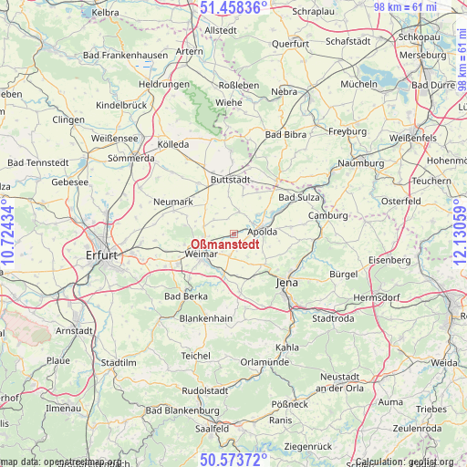
Oßmanstedt GPS coordinates[2]
51° 1' 5.34" North, 11° 25' 38.856" East
| Map corner | latitude | longitude |
|---|---|---|
| Upper-left | 51.45836°, | 10.72434° |
| Center: | 51.01815°, | 11.42746° |
| Lower-right: | 50.57372°, | 12.13059° |
| Map W x H: | 98.4×98.4 km | = 61.1×61.1mi |
| max Lat: | 55.01917° ⇑41.6% North |
| Oßmanstedt: | 51.01815° |
| min Lat: | ⇓58.4% South 47.40724° |
| min Long | Oßmanstedt | max Long |
| 5.92978° | 11.42746° | 14.98853° |
| W 73.1%⇐ | ⇒26.9% E |
Elevation
Elevation of Oßmanstedt is 199 m = 653 ft, and this is 50.1 m = 164 ft below average elevation for this country.
| Max E: |
1256 m = 4121 ft | 53.7% |
| Avg. | 249.1 m = 817 ft | |
| Oßmanstedt | 199 m = 653 ft | |
Min E: |
-5 m = -16 ft | 46.3% |
See also: Germany elevation on elevation.city.
Geographical zone
Oßmanstedt is located in North temperate zone (between Tropic of Cancer and the Arctic Circle). Distance of this North polar circle is 1728.5 km =1074 mi to North.| Distance of | km | miles | from Oßmanstedt |
|---|---|---|---|
| North Pole | 4334.4 | 2693.3 | to North |
| Arctic Circle | 1728.5 | 1074 | to North |
| Tropic Cancer | 3066.8 | 1905.6 | to South |
| Equator | 5672.7 | 3524.9 | to South |


Nearby cities:
15 places around Oßmanstedt: (largest is in red/bold)
• Apolda
6.3 km =3.9 mi,  81°
81°
• Frankendorf
5.9 km =3.7 mi,  164°
164°
• Goldbach
3.1 km =1.9 mi,  7°
7°
• Großobringen
6.8 km =4.2 mi,  284°
284°
• Kapellendorf
5.6 km =3.5 mi,  149°
149°
• Kromsdorf
4.7 km =2.9 mi,  244°
244°
• Leutenthal
5.5 km =3.4 mi,  309°
309°
• Liebstedt
4 km =2.5 mi,  331°
331°
• Niederroßla
4.3 km =2.7 mi,  66°
66°
• Pfiffelbach
4.9 km =3 mi, 12°
• Rohrbach
5.7 km =3.5 mi,  340°
340°
• Sachsenhausen
5.5 km =3.4 mi, 309°
• Umpferstedt
3.9 km =2.4 mi,  191°
191°
• Wiegendorf
3.9 km =2.4 mi,  173°
173°
• Wohlsborn
4.6 km =2.9 mi,  291°
291°
Sources, notices
• [Note1] Compared only with cities in Germany existing in our database
• [Src1] Map data: © OpenStreetMap contributors (CC-BY-SA)
• [Src2] Other city data from geonames.org with taken over terms of usage.
• [Src3] Geographical zone / Annual Mean Temperature by Robert A. Rohde @ Wikipedia
