Obersimten geodata
Obersimten (Rheinland-Pfalz) is a seat of a fourth-order administrative division; located in Germany in Europe/Berlin (GMT+2) time zone. With population of 679 people, there are 8428 cities with bigger population in this country. Compared to other cities in Germany, 80.9% of cities are located further ↑North; 85.4% of cities are located further →East and 77.4% of cities have lower elevation than Obersimten. Note1


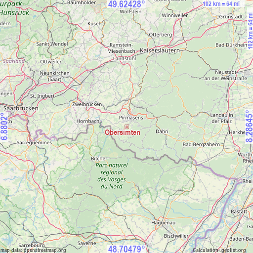
Obersimten GPS coordinates[2]
49° 10' 0.012" North, 7° 34' 59.988" East
| Map corner | latitude | longitude |
|---|---|---|
| Upper-left | 49.62428°, | 6.8802° |
| Center: | 49.16667°, | 7.58333° |
| Lower-right: | 48.70479°, | 8.28645° |
| Map W x H: | 102.2×102.2 km | = 63.5×63.5mi |
| max Lat: | 55.01917° ⇑80.9% North |
| Obersimten: | 49.16667° |
| min Lat: | ⇓19.1% South 47.40724° |
| min Long | Obersimten | max Long |
| 5.92978° | 7.58333° | 14.98853° |
| W 14.6%⇐ | ⇒85.4% E |
Elevation
Elevation of Obersimten is 415 m = 1362 ft, and this is 165.9 m = 544 ft above average elevation for this country.
| Max E: |
1256 m = 4121 ft | 22.6% |
| Obersimten | 415 m 1362 ft | |
| Avg. | 249.1 m = 817 ft | |
Min E: |
-5 m = -16 ft | 77.4% |
See also: Germany elevation on elevation.city.
Geographical zone
Obersimten is located in North temperate zone (between Tropic of Cancer and the Arctic Circle). Distance of this North polar circle is 1934.4 km =1202 mi to North.| Distance of | km | miles | from Obersimten |
|---|---|---|---|
| North Pole | 4540.2 | 2821.1 | to North |
| Arctic Circle | 1934.4 | 1202 | to North |
| Tropic Cancer | 2860.9 | 1777.7 | to South |
| Equator | 5466.8 | 3396.9 | to South |


Nearby cities:
15 places around Obersimten: (largest is in red/bold)
• Bottenbach
6.3 km =3.9 mi,  287°
287°
• Eppenbrunn
5.7 km =3.5 mi,  192°
192°
• Hilst
5.2 km =3.2 mi,  224°
224°
• Höheischweiler
7.8 km =4.8 mi,  341°
341°
• Kröppen
4.1 km =2.5 mi,  242°
242°
• Lemberg
5 km =3.1 mi,  81°
81°
• Nünschweiler
8.4 km =5.2 mi,  318°
318°
• Petersberg
7.5 km =4.7 mi,  350°
350°
• Pirmasens
4.2 km =2.6 mi,  22°
22°
• Rodalben
9.1 km =5.7 mi,  26°
26°
• Ruppertsweiler
8.4 km =5.2 mi,  66°
66°
• Schweix
6.1 km =3.8 mi,  232°
232°
• Trulben
4.2 km =2.6 mi, 223°
• Vinningen
2.6 km =1.6 mi, 243°
• Walshausen
9.1 km =5.7 mi,  307°
307°
Sources, notices
• [Note1] Compared only with cities in Germany existing in our database
• [Src1] Map data: © OpenStreetMap contributors (CC-BY-SA)
• [Src2] Other city data from geonames.org with taken over terms of usage.
• [Src3] Geographical zone / Annual Mean Temperature by Robert A. Rohde @ Wikipedia
