Kröppen geodata
Kröppen (Rheinland-Pfalz) is a seat of a fourth-order administrative division; located in Germany in Europe/Berlin (GMT+2) time zone. With population of 771 people, there are 8014 cities with bigger population in this country. Compared to other cities in Germany, 81.2% of cities are located further ↑North; 86.4% of cities are located further →East and 75.6% of cities have lower elevation than Kröppen. Note1


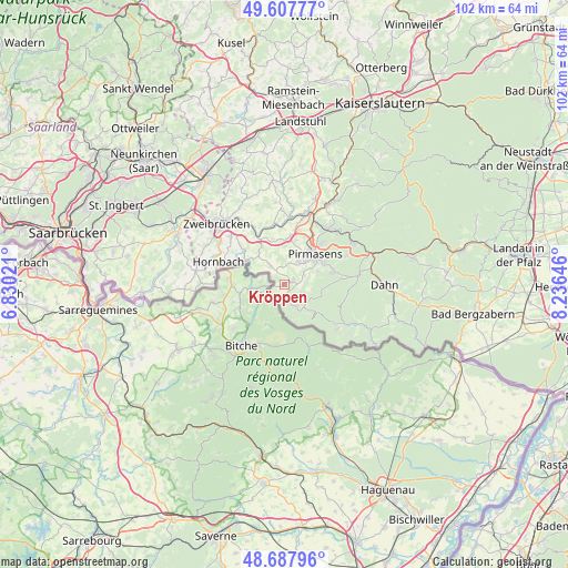
Kröppen GPS coordinates[2]
49° 9' 0" North, 7° 31' 59.988" East
| Map corner | latitude | longitude |
|---|---|---|
| Upper-left | 49.60777°, | 6.83021° |
| Center: | 49.15°, | 7.53333° |
| Lower-right: | 48.68796°, | 8.23646° |
| Map W x H: | 102.3×102.3 km | = 63.6×63.6mi |
| max Lat: | 55.01917° ⇑81.2% North |
| Kröppen: | 49.15° |
| min Lat: | ⇓18.8% South 47.40724° |
| min Long | Kröppen | max Long |
| 5.92978° | 7.53333° | 14.98853° |
| W 13.6%⇐ | ⇒86.4% E |
Elevation
Elevation of Kröppen is 402 m = 1319 ft, and this is 152.9 m = 502 ft above average elevation for this country.
| Max E: |
1256 m = 4121 ft | 24.4% |
| Kröppen | 402 m 1319 ft | |
| Avg. | 249.1 m = 817 ft | |
Min E: |
-5 m = -16 ft | 75.6% |
See also: Germany elevation on elevation.city.
Geographical zone
Kröppen is located in North temperate zone (between Tropic of Cancer and the Arctic Circle). Distance of this North polar circle is 1936.2 km =1203.1 mi to North.| Distance of | km | miles | from Kröppen |
|---|---|---|---|
| North Pole | 4542.1 | 2822.3 | to North |
| Arctic Circle | 1936.2 | 1203.1 | to North |
| Tropic Cancer | 2859 | 1776.5 | to South |
| Equator | 5465 | 3395.8 | to South |


Nearby cities:
15 places around Kröppen: (largest is in red/bold)
• Bottenbach
4.4 km =2.7 mi,  326°
326°
• Eppenbrunn
4.4 km =2.7 mi,  146°
146°
• Großsteinhausen
7.1 km =4.4 mi,  301°
301°
• Hilst
1.9 km =1.2 mi,  180°
180°
• Höheischweiler
9.3 km =5.8 mi,  7°
7°
• Kleinsteinhausen
7.4 km =4.6 mi,  318°
318°
• Lemberg
8.9 km =5.5 mi,  73°
73°
• Nünschweiler
8.4 km =5.2 mi,  346°
346°
• Obersimten
4.1 km =2.5 mi,  62°
62°
• Pirmasens
7.8 km =4.8 mi,  42°
42°
• Riedelberg
7.1 km =4.4 mi, 301°
• Schweix
2.2 km =1.4 mi,  213°
213°
• Trulben
1.4 km =0.9 mi, 147°
• Vinningen
1.5 km =0.9 mi, 62°
• Walshausen
8.3 km =5.2 mi, 333°
Sources, notices
• [Note1] Compared only with cities in Germany existing in our database
• [Src1] Map data: © OpenStreetMap contributors (CC-BY-SA)
• [Src2] Other city data from geonames.org with taken over terms of usage.
• [Src3] Geographical zone / Annual Mean Temperature by Robert A. Rohde @ Wikipedia
