Oberndorf geodata
Oberndorf (Rheinland-Pfalz) is a seat of a fourth-order administrative division; located in Germany in Europe/Berlin (GMT+2) time zone. With population of 255 people, there are 10238 cities with bigger population in this country. Compared to other cities in Germany, 71.1% of cities are located further ↑North; 80.7% of cities are located further →East and 56.8% of cities have higher elevation than Oberndorf. Note1


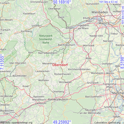
Oberndorf GPS coordinates[2]
49° 43' 0.012" North, 7° 49' 0.012" East
| Map corner | latitude | longitude |
|---|---|---|
| Upper-left | 50.16916°, | 7.11355° |
| Center: | 49.71667°, | 7.81667° |
| Lower-right: | 49.25992°, | 8.5198° |
| Map W x H: | 101.1×101.1 km | = 62.8×62.8mi |
| max Lat: | 55.01917° ⇑71.1% North |
| Oberndorf: | 49.71667° |
| min Lat: | ⇓28.9% South 47.40724° |
| min Long | Oberndorf | max Long |
| 5.92978° | 7.81667° | 14.98853° |
| W 19.3%⇐ | ⇒80.7% E |
Elevation
Elevation of Oberndorf is 176 m = 577 ft, and this is 73.1 m = 240 ft below average elevation for this country.
| Max E: |
1256 m = 4121 ft | 56.8% |
| Avg. | 249.1 m = 817 ft | |
| Oberndorf | 176 m = 577 ft | |
Min E: |
-5 m = -16 ft | 43.2% |
See also: Germany elevation on elevation.city.
Geographical zone
Oberndorf is located in North temperate zone (between Tropic of Cancer and the Arctic Circle). Distance of this North polar circle is 1873.2 km =1164 mi to North.| Distance of | km | miles | from Oberndorf |
|---|---|---|---|
| North Pole | 4479.1 | 2783.2 | to North |
| Arctic Circle | 1873.2 | 1164 | to North |
| Tropic Cancer | 2922.1 | 1815.7 | to South |
| Equator | 5528 | 3434.9 | to South |


Nearby cities:
15 places around Oberndorf: (largest is in red/bold)
• Alsenz
0 km =0 mi,  0°
0°
• Bayerfeld-Steckweiler
3.9 km =2.4 mi,  197°
197°
• Gaugrehweiler
4 km =2.5 mi,  117°
117°
• Hallgarten
5.1 km =3.2 mi,  337°
337°
• Kalkofen
2.2 km =1.4 mi,  32°
32°
• Mannweiler-Cölln
4.4 km =2.7 mi,  212°
212°
• Münsterappel
5.1 km =3.2 mi,  68°
68°
• Niedermoschel
2.2 km =1.4 mi,  327°
327°
• Oberhausen an der Appel
3.6 km =2.2 mi,  90°
90°
• Obermoschel
3.4 km =2.1 mi,  291°
291°
• Sankt Alban
5.2 km =3.2 mi,  135°
135°
• Schiersfeld
4 km =2.5 mi,  242°
242°
• Sitters
2.4 km =1.5 mi,  270°
270°
• Unkenbach
4.8 km =3 mi, 270°
• Winterborn
5.2 km =3.2 mi,  44°
44°
Sources, notices
• [Note1] Compared only with cities in Germany existing in our database
• [Src1] Map data: © OpenStreetMap contributors (CC-BY-SA)
• [Src2] Other city data from geonames.org with taken over terms of usage.
• [Src3] Geographical zone / Annual Mean Temperature by Robert A. Rohde @ Wikipedia
