Hallgarten geodata
Hallgarten (Rheinland-Pfalz) is a seat of a fourth-order administrative division; located in Germany in Europe/Berlin (GMT+2) time zone. With population of 727 people, there are 8206 cities with bigger population in this country. Compared to other cities in Germany, 69.9% of cities are located further ↑North; 81.1% of cities are located further →East and 54.9% of cities have lower elevation than Hallgarten. Note1
Administrative division(s):
- Level 1: Rheinland-Pfalz
- Level 3: Landkreis Bad Kreuznach
- Level 4: Hallgarten


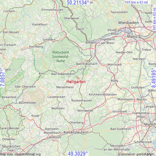
Hallgarten GPS coordinates[2]
49° 45' 33.3" North, 7° 47' 19.788" East
| Map corner | latitude | longitude |
|---|---|---|
| Upper-left | 50.21134°, | 7.0857° |
| Center: | 49.75925°, | 7.78883° |
| Lower-right: | 49.3029°, | 8.49195° |
| Map W x H: | 101×101 km | = 62.8×62.8mi |
| max Lat: | 55.01917° ⇑69.9% North |
| Hallgarten: | 49.75925° |
| min Lat: | ⇓30.1% South 47.40724° |
| min Long | Hallgarten | max Long |
| 5.92978° | 7.78883° | 14.98853° |
| W 18.9%⇐ | ⇒81.1% E |
Elevation
Elevation of Hallgarten is 257 m = 843 ft, and this is 7.9 m = 26 ft above average elevation for this country.
| Max E: |
1256 m = 4121 ft | 45.1% |
| Hallgarten | 257 m 843 ft | |
| Avg. | 249.1 m = 817 ft | |
Min E: |
-5 m = -16 ft | 54.9% |
See also: Germany elevation on elevation.city.
Geographical zone
Hallgarten is located in North temperate zone (between Tropic of Cancer and the Arctic Circle). Distance of this North polar circle is 1868.5 km =1161 mi to North.| Distance of | km | miles | from Hallgarten |
|---|---|---|---|
| North Pole | 4474.4 | 2780.3 | to North |
| Arctic Circle | 1868.5 | 1161 | to North |
| Tropic Cancer | 2926.8 | 1818.6 | to South |
| Equator | 5532.7 | 3437.9 | to South |


Nearby cities:
15 places around Hallgarten: (largest is in red/bold)
• Alsenz
5.1 km =3.2 mi,  157°
157°
• Altenbamberg
4.2 km =2.6 mi,  50°
50°
• Duchroth
4.8 km =3 mi,  303°
303°
• Feilbingert
1.2 km =0.7 mi,  44°
44°
• Hochstätten
3.3 km =2.1 mi,  75°
75°
• Kalkofen
4.3 km =2.7 mi,  132°
132°
• Lettweiler
4.9 km =3 mi,  234°
234°
• Niederhausen
4.5 km =2.8 mi,  355°
355°
• Niedermoschel
3 km =1.9 mi, 164°
• Obermoschel
3.7 km =2.3 mi,  198°
198°
• Oberndorf
5.1 km =3.2 mi, 157°
• Schloßböckelheim
5.3 km =3.3 mi,  328°
328°
• Sitters
4.8 km =3 mi,  184°
184°
• Unkenbach
5.5 km =3.4 mi,  210°
210°
• Winterborn
5.7 km =3.5 mi,  100°
100°
Sources, notices
• [Note1] Compared only with cities in Germany existing in our database
• [Src1] Map data: © OpenStreetMap contributors (CC-BY-SA)
• [Src2] Other city data from geonames.org with taken over terms of usage.
• [Src3] Geographical zone / Annual Mean Temperature by Robert A. Rohde @ Wikipedia
